Altaussee-Tressen-Tour


- All weather
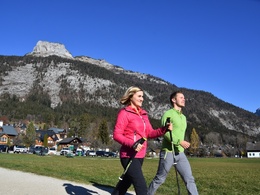
- Suitable for families
- Flatly
Interactive elevation profile
Create PDF
Tour-Details
Paths covering:
Varied alternative to the path around the lake. The route leads to the area Obertressen/Bad Aussee and back via the promenade along the river.
Technique: *
Quality of experience: ***
Recommended season:
- January
- February
- March
- April
- May
- June
- July
- August
- September
- October
- November
- December
Properties:
- Loop
- Scenic
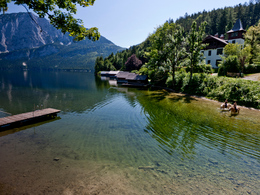
From the Kurhaus in the center of Altaussee (KM 0,0) or the hotel Seevilla in the area Seeklause (KM 0,8) the route leads you a short distance via the promenade around the lake, from KM 1,1 upwards through the forest and via small roads to the famous tree "Hofmannsthal-Linde" (KM 3,2). Later it carries on downwards to the promande "Klaus-Maria-Brandauer-Promenade" (KM 5,7) and along the river Traun back to the starting point.
Directions:
Starting the tour at the parking of the opposite site of the Kurhaus in the center of Bad Aussee a small path through the meadow leads you to the area called Seeklause and tot the hotel Seevilla (KM 0,8).
After walking 300 meters further along the lake, at KM 1,1 you turn to the right upwards until you reach at the KM 1,9 to your right a taramac road.
At KM 2,3 to the left direction to Bad Aussee.
On a hilltop (KM 2,8) the tour takes you in a forest to your left and further to a nice viewpoint at the famous tree "Hofmannsthal-Linde".
Further onwards follow the hiking path until the highest point at KM 3,7 (to the right) to KM 4,0. At the firebrigade carry on straight ahead to the path "Emil-Mariott-Weg" and at the KM 4,2 turn to the street called "Ramgutstraße".
At KM 4,4 walk again straight ahed to the street "Sigmund-Freud-Straße" and at KM 4,8 leftwards to the path "Emil-Ertl-Weg", then via a meadow and downwards through a forest.
At KM 5,7 you reach the street in direction to Altaussee and after the bridge you take a right turn to the promenade "Klaus-Maria-Brandauer-Promenade".
Always following this promenade you will reach finally your starting point in Altaussee.
Tip:
Despite given weather conditions, movement in the fresh air are recommended at any time.
This tour can be done by rainy conditions.
Safety guidelines:
Please note the exclusion of liability!
In winter also possible according to
- the snow situation
- the personal equipment
- the necessary sure-footedness
No winter service of the path at KM 2,8 to 3,4 and KM 4,9 to 5,5.
NO LIABILITY!
Equipment:
Dress accordingly to the given weather conditions.
Additional information:
TVB Ausseerland – Salzkammergut
Tel. +43 3622 54040-0
further information:
- Flatly
Getting there
Detailed information how to get to the Ausseerland – Salzkammergut you will find on our website!
Public Transit
Railway station nearby: Bad Aussee
ÖBB (train): www.oebb.at
Verbundlinie Steiermark (bus): www.busbahnbim.at
Public transport service Narzissenjet:
www.ausseerland.at/narzissenjet
Transport of bicycles not possible!
Parking
In Altaussee you will find some areas for parking.
Liable to fees!
- All weather
- Suitable for groups
- Suitable for schools
- Suitable for teenagers
- Suitable for seniors
- Suitable for single travelers
- Suitable for friends
- Suitable for couples
- Suitable for children
- Spring
- Summer
- Autumn
- Early winter
- Deep winter
Please get in touch for more information.
Fischerndorf 61
8992 Altaussee
Phone +43 3622 71643
E-Mail info.altaussee@ausseerland.at
Web www.ausseerland.at
Interactive elevation profile
Create PDF
Tour-Details
Paths covering:


