Obersdorfer Hiking Trail - Nordic Walking


- Suitable for families
- Flatly
Interactive elevation profile
Create PDF
Tour-Details
Starting place: 8983 Bad Mitterndorf
Destination: 8983 Bad Mitterndorf
duration: 2h 15m
length: 9,7 km
Altitude difference (uphill): 250m
Altitude difference (downhill): 250m
Lowest point: 786m
Highest point: 882m
difficulty: very easy
condition: easy
panoramic view: Great panorama
Paths covering:
Asphalt, Path / trail, Gravel, Street, Hiking trail, Other
powered by TOURDATA
Short description:
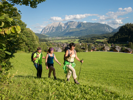
The "Obersdorfer Rundweg" is a hiking trail which makes the area between Bad Mitterndorf and its district Obersdorf accessible. 20 stations along the route explain the specific characteristics of the region.
The "Obersdorfer Rundweg" is a hiking trail which makes the area between Bad Mitterndorf and its district Obersdorf accessible. 20 stations along the route explain the specific characteristics of the region.
Enjoy the effortless and relaxing walk into the intact nature. It is truly worth it to take a breakt and observe the unique landscape.
Quality of experience: ****
Recommended season:
- April
- May
- June
- July
- August
- October
Properties:
- Loop
- Refreshment stops available
- Family friendly
- Geological highlights
- Botanical highlights
- Faunistic highlights
The basis of this landscape are a multitude of developements beginning thousands of years ago. 10 Kilometers without a noteworthy difference of heights lead you from Bad Mitterndorf to Obersdorf and again back to Bad Mitterndorf. Visitors will be informed about the formation of the countryside, the alpine scenery and all the occuring extraordinary phenomenons.
Directions:
The well structured Nordic Walking route beginns at a narrow point close to the west exit of Bad Mitterndorf. Via meadows and through a forest you will reach Obersdorf. After passing the hamlet the route makes a circle around the small hill "Kumitzberg".
From than on westwards you will get back to Bad Mitterndorf.
Safety guidelines:
Bitte beachten Sie den Haftungsausschluss!
Equipment:
Nordic-Walking Ausrüstung oder einfache Wanderkleidung, leichte Wanderschuhe.
Starting point: Westeinfahrt Bad Mitterndorf
Destination: ist der Ausgangspunkt
further information:
- Flatly
- Board possible
")
")
")
Accessibility / arrival
Parking
Parking free of charge close to the center of Bad Mitterndorf
Getting there
Detailed information how to get to the Ausseerland – Salzkammergut you will find on our website!
Parking
Parking free of charge close to the center of Bad Mitterndorf
Most economical season
- Spring
- Summer
- Autumn
Please get in touch for more information.
Bad Mitterndorf 58
8983 Bad Mitterndorf
Phone +43 3623 2444
E-Mail info.badmitterndorf@ausseerland.at
Web www.ausseerland.at
http://www.ausseerland.at
Interactive elevation profile
Create PDF
Tour-Details
Starting place: 8983 Bad Mitterndorf
Destination: 8983 Bad Mitterndorf
duration: 2h 15m
length: 9,7 km
Altitude difference (uphill): 250m
Altitude difference (downhill): 250m
Lowest point: 786m
Highest point: 882m
difficulty: very easy
condition: easy
panoramic view: Great panorama
Paths covering:
Asphalt, Path / trail, Gravel, Street, Hiking trail, Other
powered by TOURDATA


