Walk through the wilderness


- Suitable for families
- culturally interesting
Interactive elevation profile
Create PDF
Tour-Details
Paths covering:
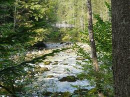
Hike along the river "Traun" downstream to Obertraun.
Technique: *
Quality of experience: *****
Recommended season:
- May
- June
- July
- August
- September
- October
Properties:
- Refreshment stops available
- Family friendly
- Cultural/historical value
Informative and exciting walk throughout on a graveld way.
Directions:
Directly at the train station in Bad Aussee starts this scenic hike path along the river "Koppentraun" to the village "Obertraun".
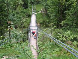
We walk along the river until the forest road leads upwards to the small locality called "Sarstein". From then on we walk downwards through the forest to the impressive rope bridge. Wthin passing this bridge the actual romantic and stunning part of this tour along the river begins.
Half-way there is a tradtional hut serving food and drinks. Walking further you will reach an old tunnel of the railway and a littel further on the stalavtite cave called "Koppenbrüllerhöhle". Passing the cave you will reach the end of this route after 10 minutes walking time.
Back to Bad Aussee we shall take the train. Time table information please get at thte train station in Bad Aussee.
Tip:
On the way there are two small inns where snacks, food and drinks are served. At the beginning one is located within the first third and the second one you will find half-way.
Highly recommended is the restaurant "Koppenrast" at the end of the walk in Obertraun for its excellent cuisine.
Safety guidelines:
Please note the exclusion of liability!
Equipment:
Hiking boots
Additional information:
Particularities:
"Koppenbrüller"-Cave in the valley
Water-bearing stalactite cave
Especially during snowmelt and after heavy rainfalls you can observe a unique natural spectacle, which you can hike through in complete safety on one of the guided tours.
On the way there are several stations with informative signs explaining the natural and historical characteristics.
Apart from the cave specific attrractions are the rope bridge and an old tunnel of the railway.
Inns on the way for taking a rest:
Traditional snack stations "Mostschänke Sarsteinrast" and "Jausenstation im Koppental", restaurant "Gasthof Koppenrast"
further information:
- Board possible
Getting there
Detailed information how to get to the Ausseerland – Salzkammergut you will find on our website!
Public Transit
ÖBB station "Koppenbrüllerhöhle"
Parking
Parking at the train station in Bad Aussee
- Spring
- Summer
- Autumn
Please get in touch for more information.
Pratergasse 388
8990 Bad Aussee
Phone +43 3622 54040 - 0
E-Mail info@ausseerland.at
Web www.ausseerland.at
Interactive elevation profile
Create PDF
Tour-Details
Paths covering:


