Cycle track R19 "Salzkammergut - Koppental - Radweg"


- culturally interesting
Interactive elevation profile
Create PDF
Tour-Details
Paths covering:
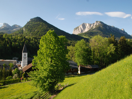
This 46 kilometer long track leads from the Ennstal via the Ausseerland in Styria to the lake Hallstättersee in Upper Austria and is suitable for the whole family.
Technique: **
Quality of experience: ***
Recommended season:
- May
- June
- July
- August
- September
- October
Properties:
- Refreshment stops available
- Cultural/historical value
This track leads from the starting point after a uphill (200 meters in altitude) to Tauplitz/Klachau and passing the ski flying hill to Bad Mitterndorf.
Aside of the traffic and mostly flat without nameable differences in altitude via the nature protection area you will reach Pichl-Kainisch. Passing the fishery along the river "Traun" we get to Bad Aussee, where we have to take the way to the railway station in order to carry on the track R19.
First via the Koppenpass, the through the valley along the river we reach the border to Upper Austria. From then on this track is call "R2 - Salzkammergut Radweg".
Directions:
Vor dem Anstieg über die Klachau (ca. 200 Höhenmeter) erblickt man Pürgg, das "Steirische Kripperl". Ein Besuch des Ortes lohnt sich!
Der Radweg führt weiter nach Tauplitz/Klachau, am Fuße der größten Natur-Skiflugschanze Kulm vorbei in den radlerfreundlichen Thermenort Bad Mitterndorf.
Abseits vom Straßenverkehr führt der Weg flach durch das Moorgebiet der "Laasen" nach Pichl-Kainisch. Nach dem Bahnübergang Kainisch biegen wir rechts in Richtung Fischereizentrum ein. Nach Durchfahrt durch die interessante Fischzuchtanstalt, immer bergab entlang der Traun führt uns ein neu angelegter Radweg bis nach Unterkainisch, welcher ein Ortsteil von Bad Aussee ist. Hier angekommen halten wir uns links und fahren bis zum Bahnhof. Dort fahren wir dann Richtung Hallstatt über den Koppenpass nach Obertraun.
Seit Mai 2011 geht die Weiterführung des >R19< zuerst über den Koppenpass, dann zum Koppental und entlang der Traun nach Obertraun (Oberösterreich). Ab der Landesgrenze wird der >R19< zum >R2< Salzkammergut-Radweg des Bundeslandes Oberösterreich. Empfehlenswert ist auch ein Besuch der Dachstein-Rieseneishöhle in Obertraun.
Das Koppental soll den Wanderern vorbehalten bleiben, daher wird um Verständnis gebeten, dass der Radweg von Bad Aussee nach Obertraun ein Stück über die Koppenpass-Landesstraße geführt wird.
Tip:
On the entire way there are possibilities for a stop. The way back can be taken by train.
Safety guidelines:
Children should be in possession of a licence and have there own appropriate equipment.
Please note the exclusion of liability!
Equipment:
The proper bicycle: Touring bicycle, roadster or mountain bike. Others such as racing bicycles are due to gravel roads not recommended.
Break-downs might occur, most of the times far away from any service providing station. Therefore to the best advantage tools, implements and appropriate material are always good to have with you.
Additional information:
More Information:
TVB Ausseerland – Salzkammergut
Tel. +43 3622 54040-0
further information:
- Board possible
Getting there
Detailed information how to get to the Ausseerland – Salzkammergut you will find on our website!
Public Transit
Railway station nearby: Stainach-Irdning
ÖBB (train): www.oebb.at
Parking
It is recommendet to use the parking at the railway station Stainach-Irdning.
- Spring
- Summer
- Autumn
Please get in touch for more information.
Pratergasse 388
8990 Bad Aussee
Phone +43 3622 54040 - 0
E-Mail info@ausseerland.at
Web www.ausseerland.at
Interactive elevation profile
Create PDF
Tour-Details
Paths covering:


