Pötschenpass to Bad Mitterndorf


Interactive elevation profile
Create PDF
Tour-Details
Paths covering:
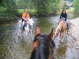
This version of a tour through the region to Bad Mitterndorf leads its visitor along the periphery of Bad Aussee outside of settlement areas.
Quality of experience: ****
Recommended season:
- May
- June
- July
- August
- September
- October
Properties:
- Scenic
- Refreshment stops available
Parts of the tour:
- Pötschenpass to the area "Sartstein" of Bad Aussee
- Bad Aussee along the river "Kainisch-Traun" to Pichl-Kainisch
- Kainisch via the mountain pasture "Steinitzenalm" to Bad Mitterndorf
Directions:
From the starting point first you have to follow the path number 693 and then at the crossing 691 in direction to the lake Sommersbergsee and finally to the parking close to it. From then on the street to the right and after some turns to the right. Via meadows you will reach the area "Sarstein". Take the street "Sarsteinstraße" to the left and again to the road "Sommersbergseestraße" to the hotel "Hotel Wasnerin.
Just before the area of the hospital and the nursing home you have to turn to the right in the road "Sießreithstraße" and follow it. Passing the restaurant "Gasthof Kalßwirt" you have take a right turn via a bridge. Then you have to turn to the left and always follow the hiking and cycle path next to the railway until the waste deposit. There you have to turn to the right and follow the river until the forest road. From now on you have to follow this forest road until you reach the street "Ödenseestraße". Crossing this you will reach again the forest and after a turn to the right via a bridge you cross fields. Again in the forest to the right you will pass a gravel pit and then always following, steet up, the signpostings to the Steinitzenalm. Leaving this mountain pasture, where in summertime there is also a small traditional hut serving refreshments, carry on on this forest road all the way to Bad Mitterndorf.
Tip:
Taking a ride on a horse on approved forest roads and paths is allowed from 08.30 a.m until two hours before dusk. Feeding areas and raised stands shall be avoided to be passed.
In wintertime horse riding is not allowed on roads which are not cleaned from the snow.
Only with a valied badge rides are allowed.
Anual fee: € 100,00
Weekly fee: € 10,00
This is available by the following persons:
Walter Hillbrand, +43 664 64 60 387, Bad Aussee
Karin Ceipek, +43 664 58 03 503, Bad Mitterndorf
Safety guidelines:
Please note the exclusion of liability!
Additional information:
More information:
TVB Ausseerland – Salzkammergut
Tel. +43 3622 54040-0
further information:
- Board possible
Details riding
Getting there
Detailed information how to get to the Ausseerland – Salzkammergut you will find on our website!
- Spring
- Summer
- Autumn
Please get in touch for more information.
Fischerndorf 61
8992 Altaussee
Phone +43 3622 71643
E-Mail info.altaussee@ausseerland.at
Web www.ausseerland.at
Interactive elevation profile
Create PDF
Tour-Details
Paths covering:


