Sandling


Interactive elevation profile
Create PDF
Tour-Details
Starting place: 8992 Altaussee
Destination: 8992 Altaussee
duration: 4h 45m
length: 9,7 km
Altitude difference (uphill): 840m
Altitude difference (downhill): 840m
Lowest point: 887m
Highest point: 1.717m
difficulty: medium
condition: very difficult
panoramic view: Dreamtour
Paths covering:
Path / trail, Gravel, Hiking trail
powered by TOURDATA
Short description:
An appealing tour in the moutains to the peak. Firm footedness and a head for heights are required.
An appealing tour in the moutains to the peak. Firm footedness and a head for heights are required.
Quality of experience: *****
Recommended season:
- May
- June
- July
- August
- September
- October
Properties:
- Refreshment stops available
- Summit route
Nice view to the region of a mountain, where in the inside salt had been stored.
Directions:
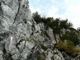
Below the parking we cross a small river and walk at the south borders of the area of the Blaa Alm until the path leads upwards into a forest and further to the mountain pasture called "Fludergrabenalm". At the big crossing there we head to the left and follow the marked route of the so-called "Via Alpina" up to another moutain pasture, the Sandlingalm, which we reach in one hour. At the end of this mountain pasture we meet a forest road coming from Upper Austria. This needs to be continued about 200 meters until we take the turn, path number 251, to the Sandling. After a steep way up we reach the first peak. Take care especially when its wet and slippery, like in autumn. Then via rocks you will reach the actual steep track to wards the peak. At the crossing with the path number 250 you must turn to the left steep upwards to the peak, which finally we will reach after 3,5 hours. For the way back we choose the path number 250 steep, but save downwards to the mountain pasture "Vordere Sandlingalm". From this point we turn to the right and walk back in a leisurely pace to the the mountain pasture "Ausseer Sandlingalm" and take the path back the Fludergrabenalm to reach finally our starting point at the Blaa Alm.
Tip:
A quick stop at the Lambacherhütte is highly recommended!
Safety guidelines:
Pay attention, difficult passages!
Please note the exclusion of liability!
Equipment:
Firm footwear, waterproof clothes and foot and drinks are in any case necessary! Be careful with sticks, sometimes they might disturb you and should be fixed on your backpack.
Starting point: Blaa Alm in Altaussee
Destination: Blaa Alm in Altaussee
further information:
- Board possible
Ausseer Sandlingalm
Lambacher Hütte
Accessibility / arrival
Parking
Parking at the Blaa Alm available!
Getting there
Detailed information how to get to the Ausseerland – Salzkammergut you will find on our website!
Parking
Parking at the Blaa Alm available!
Most economical season
- Spring
- Summer
- Autumn
Please get in touch for more information.
Fischerndorf 61
8992 Altaussee
Phone +43 3622 71643
E-Mail info.altaussee@ausseerland.at
Web www.ausseerland.at
http://www.ausseerland.at
Interactive elevation profile
Create PDF
Tour-Details
Starting place: 8992 Altaussee
Destination: 8992 Altaussee
duration: 4h 45m
length: 9,7 km
Altitude difference (uphill): 840m
Altitude difference (downhill): 840m
Lowest point: 887m
Highest point: 1.717m
difficulty: medium
condition: very difficult
panoramic view: Dreamtour
Paths covering:
Path / trail, Gravel, Hiking trail
powered by TOURDATA


