St. Agatha - Altaussee


Interactive elevation profile
Create PDF
Tour-Details
Paths covering:
Via the area "Leisling" and "Moosberg", passing the saltmines to the village Altaussee with its beautiful lake Altausseersee.
Quality of experience: ****
Recommended season:
- May
- June
- July
- August
- September
- October
Properties:
- Scenic
- Refreshment stops available
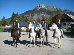
Exploring our region Ausseerland - Salzkammergut in a totally different way.
Directions:
At the restaurant "Agathawirt" you cross the main road and follow the signpostings to the mountain pasture "Halleralm". Already after 1 kilometer you turn to the right to the valley called "Leislingtal". First flat, than always upwards you follow the forest road in direction of the village Lupitsch. While ignoring all turns after a bend there is a road coming up from Lupitsch. You turn then to the left and follow the forest road via an area of moor to in direction of the area "Waldgraben". At the next turn you take the second to the right and follow all the way to the hill "Moosberg" passing the old saltmines. On top of the hill you take the right direction towards "Steinberg".
The other option straight ahead would lead you to the skiing tracks of the mountain "Sandling".
But: On the tour to Altaussee you reach a path to the old mine "Kriechbaumberg". Agter the turn there is a steep downhill until the slip road to the public saltmines "Salzwelten". Then you stay on the road downwards until the next turn where you take the old road "Alte Salzbergstraße" steep down to Altaussee.
Tip:
Taking a ride on a horse on approved forest roads and paths is allowed from 08.30 a.m until two hours before dusk. Feeding areas and raised stands shall be avoided to be passed.
In wintertime horse riding is not allowed on roads which are not cleaned from the snow.
Only with a valied badge rides are allowed.
Anual fee: € 100,00
Weekly fee: € 10,00
This is available by the following persons:
Walter Hillbrand, +43 664 64 60 387, Bad Aussee
Karin Ceipek, +43 664 58 03 503, Bad Mitterndorf
Safety guidelines:
Please note the exclusion of liability!
further information:
- Board possible
Details riding
Parking
Parkin at the restaurant in St. Agatha on request.
- Spring
- Summer
- Autumn
Please get in touch for more information.
Fischerndorf 61
8992 Altaussee
Phone +43 3622 71643
E-Mail info.altaussee@ausseerland.at
Web www.ausseerland.at
Interactive elevation profile
Create PDF
Tour-Details
Paths covering:


