Tour through the region "Rettenbach - Bad Mitterndorf"


Interactive elevation profile
Create PDF
Tour-Details
Paths covering:
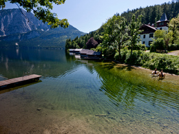
This tour is 42 kilometers long and leads throughout the entire region starting from the area Bad Ischl in Upper Austria to Bad Mitterndorf in our region Ausseerland - Salzkammergut. At the last passage from Grundlsee to Bad Mitterndorf you will reach about 1.200 meters of altitude.
It is recommended to devide this tour in stages with a break in Altaussee or Grundlsee.
Quality of experience: *****
Recommended season:
- May
- June
- July
- August
- September
- October
Properties:
- Scenic
- Refreshment stops available
The entire route of 42 kilometers in stages:
a) Rettenbachalm - via this valley and the Blaa-Alm to Altaussee (10,3 km)
b) Altaussee - Obertressen - Grundlsee (8,2 km)
c) Grundslee - Gößl (5,9 km)
d) Gößl - Salzaalm - Bad Mitterndorf 17,6 km)
Taking a ride on a horse on approved forest roads and paths is allowed from 08.30 a.m until two hours before dusk. Feeding areas and raised stands shall be avoided to be passed.
In wintertime horse riding is not allowed on roads which are not cleaned from the snow.
Only with a valied badge rides are allowed.
Anual fee: € 100,00
Weekly fee: € 10,00
This is available by the following persons:
Walter Hillbrand, +43 664 64 60 387, Bad Aussee
Karin Ceipek, +43 664 58 03 503, Bad Mitterndorf
Directions:
The Rettenbachalm leaving you take the way via this valley until a small tunnel. Passing this tunnel you reach the border of Upper Austria to Styria. Follow this slight uphill towards the Blaa-Alm. From the n on there is a graveld road until the point where you can go up to the Loser. From then on there is a taramac road all the way to Altaussee to the Hotel Seevilla.
At this Hotel you have to turn to the right, after the bridge to the left until a private house called "Haus Gasperl" , then upwards to the right and through the forest to a graveld road till you get back to a taramac road. Then downwards to a small bridge and after this bridge left upwards. Then take the left turn through a forest and in direction of the area called "Bärenmoos". After a graveld road we reach a small road where you shall take the pathway eastwards.
Reaching the area "Mosern" of the village Grundlsee you have to follow this road until the church and the restaurant "Gasthof Schraml.
In addition all the way back to Gößl you take a way which is above the lake offering beautiful lookouts to the lake and the entire particular landscape. Via small pathways, partly taramac roads and forest roads you shall reach the end of the lake. until the restaurant "Gasthaus Rostiger Anker".
From then on follow the road in direction to the area called "Wienern" until a forest road which leads left upwards. After 7 kilometers uphill you reach the highest point at 1200 meters of altitude. Finally downwards via the Kochalm you get always straight ahead to Bad Mitterndorf.
Safety guidelines:
Please note the exclusion of liability!
further information:
- Board possible
Details riding
Getting there
Detailed information how to get to the Ausseerland – Salzkammergut you will find on our website!
- Spring
- Summer
- Autumn
Please get in touch for more information.
Pratergasse 388
8990 Bad Aussee
Phone +43 3622 54040 - 0
E-Mail info@ausseerland.at
Web www.ausseerland.at
Interactive elevation profile
Create PDF
Tour-Details
Paths covering:


