Almgrabenstraße


- Flatly
Interactive elevation profile
Create PDF
Tour-Details
Paths covering:
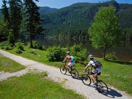
Nice tour starting from Bad Mitterndorf via the mountain pasture "Steinitznalm" to the other district Pichl-Kainisch, back to Bad Mitterndorf passing through the area Obersdorf.
Technique: ***
Quality of experience: ****
Recommended season:
- April
- May
- June
- July
- August
- September
- October
Properties:
- Loop
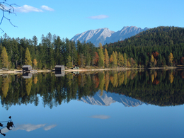
- Scenic
- Refreshment stops available
We start the tour from the center of Bad Mitterndorf westwards and head in direction of "Heilbrunn" till the turnoff "Kragl". At another turn, where there is a cattle grid, begins the rising forest road, which takes us passing the Steinitzenalm to the highest point of the route. From then on the route carries on declining gradually with one more steep part until we finally reach the "Ödenseestraße".
In the district "Kainisch" we pass the railroad crossing and take the right turn in direction back to Bad Mitterndorf (R19). Following this road passing by the possibility for a refreshment "Jausenstation Stieger", which also offers its visitor a petting zoo for children, we carry on our journey back via the district "Obersdorf" and the so-called "Laasenweg", where along you will find possibilites to rest either at the "Eselalm" or at the "Steirerhütte".
As we are at the camping site we bear left in order to get back directly to the centre of Bad Mitterndorf again.
Directions:
Wir fahren vom Ortszentrum Bad Mitterndorf in Richtung Westen. Nach der Engstelle neben der Gaststätte "Schupfers Dorfschmiede" fahren wir schräg links über den Platz und auf die Straße in Richtung Heilbrunn weiter bis wir zur Abzweigung "Kragl"gelangen. Am dortigen Weiderost beginnt die ansteigende Almgrabenstraße. Ihr folgen wir hinauf bis zur Steinitzenalm. Zu einer Einkehr bei Bernadette ist eine kurze Abfahrt nötig.
Geradeaus fahrend treffen wir auf die Kreuzung mit dem Wanderweg zum Hochmühleck. Bald sind wir auf dem höchsten Punkt unserer Runde angekommen. Nun geht es nicht mehr allzu steil bergab. Nach dem Schranken folgt noch einmal eine Steigung, ehe wir nach einer doch etwas steileren Abfahrt endgültig im Tal auf die Ödenseestraße stoßen. In Kainisch an der Fischzuchtanstalt der Österreichischen Bundesforste überqueren wir die Ödenseer Traun und zweigen vor dem Bahnübergang rechts auf den >R19< nach Bad Mitterndorf ab. Diesem folgen wir bis Mühlreith, radeln an der Jausenstation Stieger (Streichelzoo und Fischteich) vorbei zum Bahnübergang und fahren hinauf nach Knoppen. Hier fahren wir unter der Bundesstraße durch und zweigen nach rechts, hinauf nach Obersdorf ab. Wir fahren durch den Ortsteil Obersdorf wieder zur Bundesstraße, wechseln auf den Laasenweg der uns zur Eselam und zur Steirerhütte führt. Unmittelbar danach kommen wir zum Campingplatz. Linkshaltend führt uns die Straße dann wieder in das Zentrum von Bad Mitterndorf zurück.
Parkmöglichkeit: gebührenfrei bei der Grimmighalle (300 m vom Gemeindeamt entfernt)
Tip:
Various possibilities for rests, such as local taverns and traditional inns, provide you on the way with refreshments and food.
Safety guidelines:
Please note the exclusion of liability!
Equipment:
The proper bicycle: Touring bicycle, roadster or mountain bike. Others such as racing bicycles are due to gravel roads not recommended.
Break-downs might occur, most of the times far away from any service providing station. Therefore to the best advantage tools, implements and appropriate material are always good to have with you.
Additional information:
More information:
TVB Ausseerland - Salzkammergut
Tel. +43 (0)3622 / 54040-0
further information:
- Flatly
- Board possible
Getting there
B 145, Exit Bad Mitterndorf Zentrum
Detailed information how to get to the Ausseerland – Salzkammergut you will find on our website!
Public Transit
Nearest train station: Bahnhof Bad Mitterndorf-Heilbrunn
Journey planner: www.oebb.at
Flexible public means of transport: Narzissenjet
Parking
In the centre of Bad Mitterndorf is sufficient parking available.
- Spring
- Summer
- Autumn
Please get in touch for more information.
Bad Mitterndorf 58
8983 Bad Mitterndorf
Phone +43 3623 2444
E-Mail info.badmitterndorf@ausseerland.at
Web www.ausseerland.at
Interactive elevation profile
Create PDF
Tour-Details
Paths covering:


