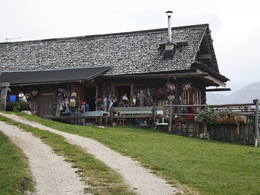
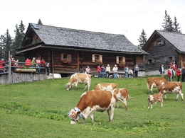
Tour to the Mountain Pasture "Plankenstein"


- pets allowed
Interactive elevation profile
Create PDF
Tour-Details
Paths covering:
Starting point "Gosau Vordertal": From sports centre the trail follows the creek before it branch off to the right hand through the woods. Follow the trail W 513 to Plankensteinalm.
Starting point "Gosau Mittertal": Parking at "Hornspitzbahn". Follow the trail W 511 to "Schäferalm". You can go straight on the trail W 513 to Plankensteinalm or make a short detour an visit "Löckernmoos". Its beautiful nature is peerless. Pass "Triamerhütte" an go on to Plankensteinalm.
Starting Point "Gosau Hintertal": The trails takes you on forest roads through the woods. On trail W 644 you pass "Badstubnhütte" and the beautiful "Löckernmoos" before you reach Plankensteinalm.
The Leutgebhütte is no longer open!
Experience a 360° panorama tour through Gosau valley...
Mountain rescue: 140
This trail is, depending on the weather, accessible from June till September.
by car
from Salzburg:
Motorway exit Golling via B162 Abtenau and B166 to Gosau
from Linz:
Motorway exit Regau on Salzkammergut street B145 towards Gmunden and Bad Ischl to Bad Goisern, in Bad Goisern turn right onto B166, at the Gosaumühle junction turn right towards Gosau
from Vienna/Graz:
Motorway exit Liezen on the B320, in Trautenfels turn on Salzkammergut street B145 to Bad Aussee, turn on Koppen street through Obertraun and Hallstatt, at the Gosaumühle junction turn left towards Gosau
from Villach:
Tauern motorway to exit “Eben im Pongau”, via the B166 Pass Gschütt federal road to Gosau
by train
Attnang-Puchheim - Stainach-Irdning lines
Arrival by train in "Steeg / Gosau" then continue with bus 542 in the direction Gosausee
By bus
Bus 470 (Abtenau - Gosau) direction Gosau, stop Gosau Abzw. Pass Gschütt
Bus 542 (Bad Ischl - Gosausee) direction Gosausee, stops Haltestelle: Gosau Klaushof, Gosau Bärnausiedlung, Gosau Ressenbachweg, Gosau Vordertal B166, Gosau Ramsau B166, Gosau, Gemeindeamt, Abzw. Pass Gschütt, Gosau Wirtsweg, Gosau Leitenweg, Gosau Schüttmannweg, Mittertal b. Gosau Ort, Mittertal, Hornspitzlift, Hintertal b. Gosau Falmbach, Hintertal b. Gosau Mühlradl, Hintertal b. Gosau Ort, Hintertal b. Gosau Madlgasse, Hintertal b. Gosau Schmiedweg,
Detailed information on the respective train and bus times can be found at https://www.oebb.at/en/ (train) and https://www.postbus.at/en(bus).
- Parking space: 5
no parking fees
- Suitable for groups
- Pets allowed
- Suitable for single travelers
- Suitable for friends
- Suitable for couples
- Summer
- Autumn
Please get in touch for more information.
Gosauseestraße 5
4824 Gosau
Phone +43 5 95095 - 20
Fax machine +43 5 95095 - 74
E-Mail gosau@dachstein-salzkammergut.at
Web dachstein.salzkammergut.at/
Web www.leutgebhof.at
https://www.leutgebhof.at
You can also visit us on
Visit us on Facebook Visit us on Instagram Visit us on Pinterest Visit our videochannel on YouTube Wikipedia")
Interactive elevation profile
Create PDF
Tour-Details
Paths covering:


