4 Mountains 3 Lakes - Stage 4: Mondsee – Fuschl am See


Interactive elevation profile
Create PDF
Tour-Details
Starting place: 5310 Mondsee am Mondsee
Destination: 5330 Fuschl am See
duration: 4h 51m
length: 12,1 km
Altitude difference (uphill): 796m
Altitude difference (downhill): 604m
Lowest point: 483m
Highest point: 1.234m
difficulty: difficult
condition: difficult
panoramic view: Great panorama
Paths covering:
Asphalt, Climbing mount, Path / trail, Gravel, Hiking trail
powered by TOURDATA
This is one stage of the Long Distance Hike in the Salzkammergut Lake District. It leads from the centre of Mondsee over the peaks of the Schober and Frauenkopf mountains to Fuschl am See. Here again luggage transportation is offered. Please note that when conditions are wet, the Schober and Frauenkopf route can be dangerous. Should this be the case, then please shorten your tour at the Gasthof Wartenfels and take the direct path down to Fuschl am See.
This tour starts in the centre of the resort of Mondsee and leads towards Schwarzindien along the lakeside. At the silver-birch tree alley, cross the main road and turn up past the Culture Centre Höribach into an alley of horse chestnut trees. This road leads upwards on quiet traffic-free tracks to a farm. Here you pass through a farm gate (please close) into a wood and on to the area of Obernberg with another farm. After a long curve on a farm track, turn left onto a forest track and then after a few metres right into the woods again. This path then climbs upwards to a further forest track. Cross this track and follow the wooded path up to Gasthof Wartenfels. Here is an ideal stop for refreshments before one starts the tour up the Schober mountain.
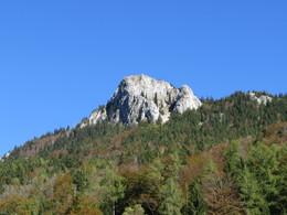
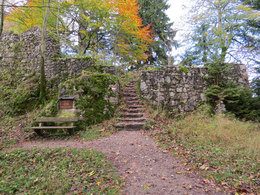
After a rest one can climb to the Wartenfels ruins, a former strong-hold with expansive views towards Salzburg. Return to the Gasthof Wartenfels for the start of the tour to the summit of the Schober. The hike leads serpentine uphill with lovely views of Lake Fuschl en route. Please be careful by wet weather as the climb is very exacting. In the upper part of the ascent there is a wire hawser to hold-on-to for your safety.
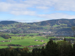
From the summit one has a fantastic view of seven lakes. The descent begins left of the shelter hut beneath the ridge. After a short while one has the possibility to climb to the neighbouring peak of the Frauenkopf. Here too you will have expansive views of Lake Fuschl and the mountain range of the Osterhorn group.
The descent from the Frauenkopf is also a stoney path, partly over gravel fields – please be careful – until you join the hiking path back to Fuschl am See. If in need of refreshment, turn back to Gasthof Wartenfels.
The route back to Fuschl passes through a typical mixed forest until one arrives at the golf course of Hotel Ebner´s Waldhof where the landscape opens up again. Now it is not far to Lake Fuschl. Take the opportunity to swim in the crystal clear waters of Lake Fuschl at the Fuschlsee bathing beach.
This tour starts in the centre of the resort of Mondsee and leads towards Schwarzindien along the lakeside. At the silver-birch tree alley, cross the main road and turn up past the Culture Centre Höribach into an alley of horse chestnut trees. This road leads upwards on quiet traffic-free tracks to a farm. Here you pass through a farm gate (please close) into a wood and on to the area of Obernberg with another farm. After a long curve on a farm track, turn left onto a forest track and then after a few metres right into the woods again. This path then climbs upwards to a further forest track. Cross this track and follow the wooded path up to Gasthof Wartenfels. Here is an ideal stop for refreshments before one starts the tour up the Schober mountain.
After a rest one can climb to the Wartenfels ruins, a former strong-hold with expansive views towards Salzburg. Return to the Gasthof Wartenfels for the start of the tour to the summit of the Schober. The hike leads serpentine uphill with lovely views of Lake Fuschl en route. Please be careful by wet weather as the climb is very exacting. In the upper part of the ascent there is a wire hawser to hold-on-to for your safety.
From the summit one has a fantastic view of seven lakes. The descent begins left of the shelter hut beneath the ridge. After a short while one has the possibility to climb to the neighbouring peak of the Frauenkopf. Here too you will have expansive views of Lake Fuschl and the mountain range of the Osterhorn group.
The descent from the Frauenkopf is also a stoney path, partly over gravel fields – please be careful – until you join the hiking path back to Fuschl am See. If in need of refreshment, turn back to Gasthof Wartenfels.
The route back to Fuschl passes through a typical mixed forest until one arrives at the golf course of Hotel Ebner´s Waldhof where the landscape opens up again. Now it is not far to Lake Fuschl. Take the opportunity to swim in the crystal clear waters of Lake Fuschl at the Fuschlsee bathing beach.
Starting point: town centre Mondsee
Destination: town centre Fuschl am See
")

")

")
")

Accessibility / arrival
Stage starts in the town centre of Mondsee
- Parking space: 350
- Parking area for disabled: 20
- Bus parking space: 20
none, please note short term parking areas
Other special suitabilities
Attention! When raining or at wet conditions please do not ascend to the "Schober" and/or "Frauenkopf". Trail is very dangerous and must not be walked. Use the short cut directly to "Fuschl" at the restaurant "Forsthaus Wartenfels" instead.
Most economical season- Summer
- Autumn
Please get in touch for more information.
Dorfplatz 1
5330 Fuschl am See
Phone +43 6226 8384 - 11
E-Mail incoming@fuschlseeregion.com
Web fuschlsee.salzkammergut.at/4berge3s…
Web 4berge3seen.at
https://fuschlsee.salzkammergut.at/4berge3seen.html
http://4berge3seen.at
http://4berge3seen.at
Interactive elevation profile
Create PDF
Tour-Details
Starting place: 5310 Mondsee am Mondsee
Destination: 5330 Fuschl am See
duration: 4h 51m
length: 12,1 km
Altitude difference (uphill): 796m
Altitude difference (downhill): 604m
Lowest point: 483m
Highest point: 1.234m
difficulty: difficult
condition: difficult
panoramic view: Great panorama
Paths covering:
Asphalt, Climbing mount, Path / trail, Gravel, Hiking trail
powered by TOURDATA


