Wartenfels - ruin with view


- Flatly
Interactive elevation profile
Create PDF
Tour-Details
Path number: 24
Starting place: 5310 St. Lorenz am Mondsee
Destination: 5310 St. Lorenz am Mondsee
duration: 3h 52m
length: 6,6 km
Altitude difference (uphill): 673m
Altitude difference (downhill): 673m
Lowest point: 652m
Highest point: 1.259m
difficulty: difficult
condition: difficult
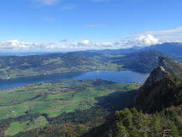
panoramic view: Great panorama
Paths covering:
Hiking trail
powered by TOURDATA
This hike is partly very demanding. The Schober summit has rope insurance and is partially exposed. Please make sure that you have alpine equipment when the ground is wet. Attention even with children - it should not be their first hike.
The trail is marked as trail no. 9. It is a forest path to Wartenfels. It is worth climbing the ruin and enjoying the view. From there it is an alpine trail that requires appropriate equipment, fitness and surefootedness.
For the ascent to Schober and the tour over the Frauenkopf there is also sufficient parking space at Gasthaus Wartenfels.
There is no marked path to the treasure wall.
The Franner martyr (pos. 263) is very difficult to find in the forest above a forest road.
")
")
")
")
")
")
")
")
")
")
- Suitable for seniors
- Suitable for friends
- Suitable for couples
- Summer
- Autumn
Please get in touch for more information.
Kirchengasse 1
5310 Mondsee am Mondsee
Phone +43 6232 4166
E-Mail pfarre.mondsee@dioezese-linz.at
Web www.pfarre-mondsee.com
http://www.pfarre-mondsee.com
Interactive elevation profile
Create PDF
Tour-Details
Path number: 24
Starting place: 5310 St. Lorenz am Mondsee
Destination: 5310 St. Lorenz am Mondsee
duration: 3h 52m
length: 6,6 km
Altitude difference (uphill): 673m
Altitude difference (downhill): 673m
Lowest point: 652m
Highest point: 1.259m
difficulty: difficult
condition: difficult
panoramic view: Great panorama
Paths covering:
Hiking trail
powered by TOURDATA


