Tauplitz Gwendlingstein


- Flatly
Interactive elevation profile
Create PDF
Tour-Details
Paths covering:
Beautiful tour offering nice lookouts!
Technique: *****
Quality of experience: *****
Recommended season:
- May
- June
- July
- August
- September
- October
Properties:
- Loop
- Summit route
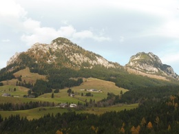
From the center of the village Tauplitz or other points a well-marked path leads to the mountain "Gwendlingstein" (1645 meters) and further to the mountain "Hechlstein" (1814 meters).
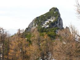
The ascent to the mountain "Hechlstein" ist steep, full of rocks and only partly secured!
Directions:
From the center of the village in Tauplitz in the east direction well-marked on pathes and forest roads.
Upwards to the peak of the Gwendlingstein at 1645 meters.
Further eastwards to the Hechlstein at 1814 meters. This path is steep, rocky and in some parts not secured.
The round trip furter to the east and then on the south of the two summits back.
A brief version and easier alternative is to take a turn between the Gwendlingstein and the Hechlstein and walk back a small round.
Tip:
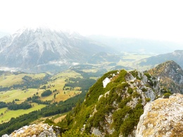
Beautiful view to the village Tauplitz, to the mountain pasture "Gnanitzalm", to the Totes Gebirge, to the neighboured region Ennstal and of course to the Grimming.
Safety guidelines:
Please note the exclusion of liability!
Equipment:
Firm footwear is highly recommended and necessary especially due to the rocky parts.
Additional information:
More information:
Tourismusverband Ausseerland - Salzkammergut
Tel. +43 (0)3622 / 54040-0
further information:
- Flatly
")
Getting there
Nähere Information zur Anreise in das Ausseerland – Salzkammergut finden Sie auch auf unserer Homepage!
Public Transit
Railway station nearby: Tauplitz
ÖBB (train): www.oebb.at
Verbundlinie Steiermark (bus): www.busbahnbim.at
Parking
Parking available free of charge!
- Spring
- Summer
- Autumn
Please get in touch for more information.
Tauplitz 70
8983 Bad Mitterndorf
Phone +43 3688 2446
E-Mail info.tauplitz@ausseerland.at
Web www.ausseerland.at
Interactive elevation profile
Create PDF
Tour-Details
Paths covering:


