Pichlmoos cross-country ski-track (K2)


- Flatly
Interactive elevation profile
Create PDF
Tour-Details
Starting place: 8984 Bad Mitterndorf
Destination: 8984 Bad Mitterndorf
duration: 0h 46m
length: 3,6 km
Altitude difference (uphill): 26m
Altitude difference (downhill): 26m
Lowest point: 766m
Highest point: 791m
difficulty: very easy
condition: easy
panoramic view: Great panorama
Paths covering:
snow
powered by TOURDATA
Trail not in operation
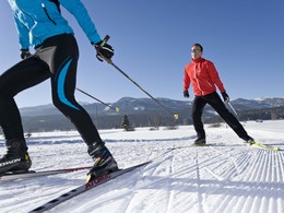
The cross-country ski-track „Pichlmoos Loipe“ is part of the more than 200 kilometers long Salzkammergut trails.
Perfect for beginners this effortless track without nameable differences in altitude leads throughout a beautiful landscape.From the starting point the track leads along the river "Riedlbachtraun" towards the bridge "Riedlbachbrücke". At that point you can decide if you will take the route to the lake Ödensee or back to the starting point.
Starting point: Sportstüberl Pichl-Kainisch
Destination: Sportstüberl Pichl-Kainisch
further information:
- Flatly
- Board possible
Details - Trail
- Nordic skiing facilities: Marked Nordic skiing run
- Type of Nordic skiing run: Classic + skating
Accessibility / arrival
Public Transit
Railway station nearby: Pichl-Kainisch
Parking
Parking available!
Getting there
Detailed information how to get to the Ausseerland – Salzkammergut you will find on our website!
Public Transit
Railway station nearby: Pichl-Kainisch
ÖBB (train): www.oebb.at
Parking
Parking available!
Payment methods
Debit and credit cards
ATM card
Other payment methods
Cash payment
Most economical season
- Early winter
- Deep winter
Please get in touch for more information.
Bad Mitterndorf 58
8983 Bad Mitterndorf
Phone +43 3623 2444
E-Mail info.badmitterndorf@ausseerland.at
Web www.ausseerland.at
http://www.ausseerland.at
Interactive elevation profile
Create PDF
Tour-Details
Starting place: 8984 Bad Mitterndorf
Destination: 8984 Bad Mitterndorf
duration: 0h 46m
length: 3,6 km
Altitude difference (uphill): 26m
Altitude difference (downhill): 26m
Lowest point: 766m
Highest point: 791m
difficulty: very easy
condition: easy
panoramic view: Great panorama
Paths covering:
snow
powered by TOURDATA


