Kahlseneck - Route


- Suitable for families
- Flatly
Interactive elevation profile
Create PDF
Tour-Details
Starting place: 8992 Altaussee
Destination: 8992 Altaussee
duration: 1h 15m
length: 3,7 km
Altitude difference (uphill): 125m
Altitude difference (downhill): 125m
Lowest point: 719m
Highest point: 817m
difficulty: very easy
condition: very easy
panoramic view: Great panorama
Paths covering:
Asphalt, Gravel, Other
powered by TOURDATA
Short description:
A short lake-tour with a stop and historical aspects.
A short lake-tour with a stop and historical aspects.
Quality of experience: ***
Recommended season:
- January
- February
- March
- April
- May
- June
- July
- August
- September
- October
- November
- December
Properties:
- Loop
- Scenic
- Refreshment stops available
- Family friendly
Directions:
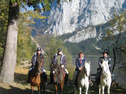
First you take the right direction towards the church of Altaussee. At the Seehotel you must take the left turn and passing the graveyard you will reach the traditional inn "Jausenstation Kahlseneck", which is located directly next to the lake. After a relaxing stop you carry on and you shall see two monuments: Theodor Herzl (founder of the state Israel) and Paul Preuß (famous mountaineer). Following the theme-path "Via Artis", which is called "Ritter von Arneth-Weg", you reach furhteron the district Posern, above Altaussee, where you will enjoy an outstanding view. Finally an asphaltic road takes you via the local pony yard "Ponyhof Schartner" back to the center of Altaussee.
Tip:
Taking a ride on a horse on approved forest roads and paths is allowed from 08.30 a.m until two hours before dusk. Feeding areas and raised stands shall be avoided to be passed.
In wintertime horse riding is not allowed on roads which are not cleaned from the snow.
Only with a valied badge rides are allowed.
Anual fee: € 100,00
Weekly fee: € 10,00
This is available by the following persons:
Walter Hillbrand, +43 664 64 60 387, Bad Aussee
Karin Ceipek, +43 664 58 03 503, Bad Mitterndorf
Safety guidelines:
You are kindly asked to remove horse droppings since this route mostly is a pathway as well!
Please note the exclusion of liability!
Starting point: Municipial office of Altaussee
Destination: Starting point
further information:
- Flatly
- Board possible
Details riding
Accessibility / arrival
Parking
Parking available at the starting point, on the opposite site of the municipial office of Altaussee
Getting there
Detailed information how to get to the Ausseerland – Salzkammergut you will find on our website!
Parking
Parking available at the starting point, on the opposite site of the municipial office of Altaussee
Liable to fees!
Most economical season
- Spring
- Summer
- Autumn
- Early winter
- Deep winter
Please get in touch for more information.
Fischerndorf 61
8992 Altaussee
Phone +43 3622 71643
E-Mail info.altaussee@ausseerland.at
Web www.ausseerland.at
http://www.ausseerland.at
Interactive elevation profile
Create PDF
Tour-Details
Starting place: 8992 Altaussee
Destination: 8992 Altaussee
duration: 1h 15m
length: 3,7 km
Altitude difference (uphill): 125m
Altitude difference (downhill): 125m
Lowest point: 719m
Highest point: 817m
difficulty: very easy
condition: very easy
panoramic view: Great panorama
Paths covering:
Asphalt, Gravel, Other
powered by TOURDATA


