Zimitzalm


- Suitable for families
- Flatly
Interactive elevation profile
Create PDF
Tour-Details
Starting place: 8993 Grundlsee
Destination: 8993 Grundlsee
duration: 3h 30m
length: 8,0 km
Altitude difference (uphill): 530m
Altitude difference (downhill): 504m
Lowest point: 721m
Highest point: 1.153m
difficulty: easy
condition: medium
panoramic view: Dreamtour
Paths covering:
Path / trail, Gravel, Street, Hiking trail
powered by TOURDATA
Short description:
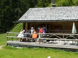
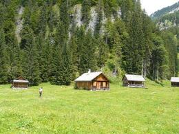
An effortless hike through the forest providing shade, passing a waterfall you will reach the mountain pasture "Zimitzalm", where there is a hut servin refreshments from the own production. The round will be continued via the mountain pasture "Schweiberalm".
An effortless hike through the forest providing shade, passing a waterfall you will reach the mountain pasture "Zimitzalm", where there is a hut servin refreshments from the own production. The round will be continued via the mountain pasture "Schweiberalm".
Quality of experience: ****
Recommended season:
- May
- June
- July
- August
- September
- October
Properties:
- Loop
- Scenic
- Refreshment stops available
- Family friendly
Directions:
From the restaurant "Gasthaus Murbodenhüttl" in Grundlsee we walk back about 50 meters, after a bridge to the right on a forest road to a gravel pit. After a fish farm a pathway turns to the left upwards. We follow always the well-marked way, pass a waterfall and reach quite soon the mountain pasture. After a break at the hut "Seidlhütte" in the Zimitzalm we carry on walking upwards until we reach a forest road. We follow this to the area called "Schweiberalm". Then again we carry on always along the marking towards Grundlsee. On a path through the forest we reach soon another graveld road, which we follow until the valley. Finally at the main road you turn to the right and reach soon the restaurant "Gasthaus Murbodenhüttl" in Grundlsee.
Safety guidelines:
Please note the exclusion of liability!
Additional information:
More information
TVB Ausseerland – Salzkammergut
Tel. +43 3622 54040-0
Starting point: Restaurant "Gasthaus Murbodenhüttl" in Grundlsee
Destination: Restaurant "Gasthaus Murbodenhüttl" in Grundlsee
further information:
- Flatly
- Board possible
Accessibility / arrival
Public Transit
Railway station nearby: Bad Aussee
Parking
Parking directly at the starting point available.
Getting there
Detailed information how to get to the Ausseerland – Salzkammergut you will find on our website!
Public Transit
Railway station nearby: Bad Aussee
ÖBB (train): www.oebb.at
Verbundlinie Steiermark (bus): www.busbahnbim.at
Public transport service Narzissenjet:
www.ausseerland.at/narzissenjet
Parking
Parking directly at the starting point available.
Most economical season
- Spring
- Summer
- Autumn
Please get in touch for more information.
Mosern 25
8993 Grundlsee
Phone +43 3622 8666
E-Mail info.grundlsee@ausseerland.at
Web www.ausseerland.at
http://www.ausseerland.at
Interactive elevation profile
Create PDF
Tour-Details
Starting place: 8993 Grundlsee
Destination: 8993 Grundlsee
duration: 3h 30m
length: 8,0 km
Altitude difference (uphill): 530m
Altitude difference (downhill): 504m
Lowest point: 721m
Highest point: 1.153m
difficulty: easy
condition: medium
panoramic view: Dreamtour
Paths covering:
Path / trail, Gravel, Street, Hiking trail
powered by TOURDATA


