Blaa Alm cross-country ski-track


- Suitable for families
- Flatly
Interactive elevation profile
Create PDF
Tour-Details
Starting place: 8992 Altaussee
Destination: 8992 Altaussee
duration: 0h 48m
length: 3,6 km
Altitude difference (uphill): 41m
Altitude difference (downhill): 39m
Lowest point: 863m
Highest point: 900m
difficulty: easy
condition: medium
panoramic view: Great panorama
Paths covering:
snow
powered by TOURDATA
Trail not in operation
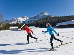
Excellent cross-country skiing-track for classic and skating style. Except few rises this track is not too difficult.
This cross-country skiing-track is located at the foot of the mountain "Loser" in a unique landscape. Possibilities for a rest offer the traditional inn "Blaa Alm" or others in the Loser Skiarena.Passing snow-covered meadow until a small rise, soon you shall reach the "Blaa Alm", an area of outstanding beauty. Enjoy the course which leads around the Blaa Alm.
Advanced or intermediate cross-country skiers might decide to carry on to a nice mountain pasture called "Rettenbachalm" and back through the forest. After a rise you get back to the "Blaa Alm" and finally to the starting point in the Loser Skiarena.
Starting point: Loser Skiarena - Ski School Haim
Destination: Loser Skiarena - Ski School Haim
further information:
- Flatly
- Board possible
Details - Trail
- Nordic skiing facilities: Marked Nordic skiing run
- Type of Nordic skiing run: Classic + skating
- free
")
")
")

Accessibility / arrival
Public Transit
Nächstgelegener Bahnhof: Bad Aussee
Fahrplanauskünfte unter www.oebb.at
Parking
Parking is available in the Loser Skiarena!
Getting there
Detailed information how to get to the Ausseerland – Salzkammergut you will find on our website!
Public Transit
Nächstgelegener Bahnhof: Bad Aussee
Fahrplanauskünfte unter www.oebb.at
Parking
Parking is available in the Loser Skiarena!
- Free entry
Most economical season
- Deep winter
Please get in touch for more information.
Fischerndorf 61
8992 Altaussee
Phone +43 3622 71643
E-Mail info.altaussee@ausseerland.at
Web www.ausseerland.at
http://www.ausseerland.at
Interactive elevation profile
Create PDF
Tour-Details
Starting place: 8992 Altaussee
Destination: 8992 Altaussee
duration: 0h 48m
length: 3,6 km
Altitude difference (uphill): 41m
Altitude difference (downhill): 39m
Lowest point: 863m
Highest point: 900m
difficulty: easy
condition: medium
panoramic view: Great panorama
Paths covering:
snow
powered by TOURDATA


