Woising to the Appelhaus


Interactive elevation profile
Create PDF
Tour-Details
Starting place: 4802 Ebensee
Destination: 8993 Grundlsee
duration: 2h 15m
length: 4,1 km
Altitude difference (uphill): 450m
Altitude difference (downhill): 38m
Lowest point: 1.625m
Highest point: 2.064m
difficulty: easy
condition: medium
panoramic view: Dreamtour
Paths covering:
Path / trail
powered by TOURDATA
Short description:
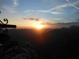
The hut "Albert Appelhaus" you will reach from Grundlsee or from Altaussee in about 3,5 to 4 hours walking time. In order to reach the sunrise at the peak of the mountain "Woising" on time, you have the leave the Albert Appelhaus about 2,5 hours in advance. It is worth it!
The hut "Albert Appelhaus" you will reach from Grundlsee or from Altaussee in about 3,5 to 4 hours walking time. In order to reach the sunrise at the peak of the mountain "Woising" on time, you have the leave the Albert Appelhaus about 2,5 hours in advance. It is worth it!
Quality of experience: *****
Recommended season:
- July
- August
- September
Properties:
- Scenic
- Refreshment stops available
- Summit route
It is not too challenging. The path leads via the mountain pasture and through fields of mountain pines to the ascent of the Woising. The last part leads via a more steeper hillside to the peak.
Directions:
About 150 meters on the hiking trail 201 in direction to the Pühringerhütte we turn to the left and thus take the path number 232. After about 850 meters we follow straight ahead to the lake "Henarsee". After that there is a part, which is more steep up to the plateau. Via a rich field of mountain pines we reach the last ascent to the peak.
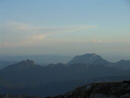
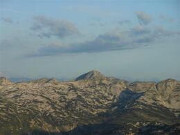
Breathtaking lookouts and the sights of numerous chamois will make you enjoy this unique experience.
Safety guidelines:
Please note the exclusion of liability!
Equipment:
Firm footwear is necessary and hiking equipment recommended.
Additional information:
More information
TVB Ausseerland – Salzkammergut
Tel. +43 3622 54040-0
Starting point: "Albert Appelhaus"
Destination: " Hoher Woising (2064 m)"
further information:
- Board possible
")
Accessibility / arrival
Getting there
Detailed information how to get to the Ausseerland – Salzkammergut you will find on our website!
Most economical season
- Summer
- Autumn
Please get in touch for more information.
Mosern 25
8993 Grundlsee
Phone +43 3622 8666
E-Mail info.grundlsee@ausseerland.at
Web www.ausseerland.at
http://www.ausseerland.at
Interactive elevation profile
Create PDF
Tour-Details
Starting place: 4802 Ebensee
Destination: 8993 Grundlsee
duration: 2h 15m
length: 4,1 km
Altitude difference (uphill): 450m
Altitude difference (downhill): 38m
Lowest point: 1.625m
Highest point: 2.064m
difficulty: easy
condition: medium
panoramic view: Dreamtour
Paths covering:
Path / trail
powered by TOURDATA


