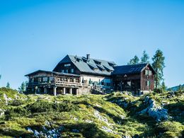
Lahngangseen & Pühringerhütte


Interactive elevation profile
Create PDF
Tour-Details
Paths covering:
For beginners a heavy daily tour. The hut "Pühringerhütte" is another starting point for long tours in to the mountains of the Totes Gebirge or as a station to rest during the crossing to the valley called Almtal in Upper Austria.
Quality of experience: *****
Recommended season:
- May
- June
- July
- August
- September
- October
Properties:
- Scenic
- Refreshment stops available
- Geological highlights
- Botanical highlights
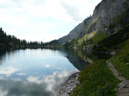
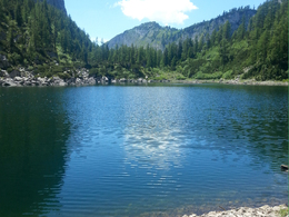
The two lakes "Lahngangseen" are located halfway to the hut Pühringerhütte. The first one is basicly bigger than the other one, which is also more difficult to reach.
After passing the lakes the way takes you accompinied by unique formations of the landscape to the mentioned hut Pühringerhütte.
Directions:
From the bus stop/parking in the area of Schachen a forest road leads to the north, later in a turn to the east until the first signpostings of the way to the Pühringerhütte. Later the path crotches again where you follow the walk with the number 214. After you cross kind of a field of rocks and reach after a steep uphill the first lake "Vorderer Lahngangsee" in 1500 meters of altitude.
Walking along the path next to the lake after about 40 minutes you shall reach the Pühringerhütte.
Safety guidelines:
Please note the exclusion of liability!
Equipment:
A well prepared backpack will ensure a nice tour: Heavy items shall be packed first. Other implements such as sunglasses, camera or maps on top. A bottle of water should be always at hand!
Emergency equipment and a first-aid kit are highly recommended to have with you for every tour!
Generally be aware of quick changes regarding the weather and appropriate clothing.
Compact hiking boots guarantee treading resistance for your adventure.
Additional information:
Pühringerhütte
Weitere Informationen:
TVB Ausseerland - Salzkammergut
Tel. +43 (0)3622 / 54040-0
further information:
- Board possible
Getting there
Detailed information how to get to the Ausseerland – Salzkammergut you will find on our website!
Public Transit
Railway station nearby: Bad Aussee
ÖBB (train): www.oebb.at
Verbundlinie Steiermark (bus): www.busbahnbim.at
Public transport service Narzissenjet:
www.ausseerland.at/narzissenjet
Parking
Parking available directly at the starting point.
- Spring
- Summer
- Autumn
Please get in touch for more information.
Mosern 25
8993 Grundlsee
Phone +43 3622 8666
E-Mail info.grundlsee@ausseerland.at
Web www.ausseerland.at
Interactive elevation profile
Create PDF
Tour-Details
Paths covering:


