From Ödensee to the Grundlsee


- Flatly
Interactive elevation profile
Create PDF
Tour-Details
Paths covering:
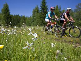
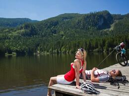
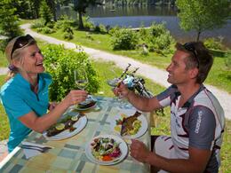
A beautiful tour from Grundlsee to Ödensee. A culinary stop is recommended at the Ödensee.
Technique: *
Quality of experience: ****
Recommended season:
- April
- May
- June
- July
- August
- September
- October
Properties:
- Loop
- Scenic
- Refreshment stops available
- Botanical highlights
At the parking on the opposite side of the tourism office in Grundlsee, next to the hotel "Seehotel Grundlsee", we start in direction to Bad Aussee. 500 m after the beginning of the lake we turn to the left in direction to Kainisch, again to the right at the carpentry. At the next crossing we carry on driving straight ahead via the area "Gallhof", then up to the area "Hintenkogel". Reaching the lift a graveled road to the left brings us to the church "St. Leonhard". On the road called "Alte Salzstraße" we turn to the right and again to the left, downwards via the "Scheibnergasse", passing the area "Eselsbach" to the area "Sießreith". At the main road you have to turn to the left, passing the restaurant "Kalßwirt" until the bridge and then to the right where a path takes you bellow the railway to the well marked cycle path.
After the fishing center in Pichl-Kainisch we follow the street "Ödenseestraße" until we reach the lake, which we drive around. We follow the marked cycle path and enjoy the beauty of the moorlands until we get back to the fishing center again.
There we cross the grade crossing and go to the village Kainisch, where we follow the marked tour "R 61" which is the "Ausseer Radweg" upwards to the pass called "Radling". Please pay attention to the traffic at this part of the tour. We carry on this road until there is the turn to Grundlsee to the right hand. From then on this street takes us back to the starting point.
Directions:
Vom Parkplatz beim Informationsbüro, unmittelbar neben dem Seehotel fahren wir Richtung Bad Aussee. 500 m nach der Seeklause zweigen wir nach links ab Richtung Kainisch. Beim Zimmereibetrieb fahren wir gleich wieder rechts. Bei der nächsten Kreuzung fahren wir geradeaus durch die Siedlung am "Gallhof" und dann wieder geradeaus hinauf zum Hintenkogel. Auf der Anhöhe führt ein Schotterweg nach links hinüber zur Klavarienbergkirche St. Leonhard. Auf der Alten Salzstraße angekommen fahren wir nach rechts und gleich wieder links, dann die Scheibnergasse hinunter, durch Eselsbach ins Sießreith. An der Hauptstraße fahren wir nach links, am Gasthof Kalßwirt vorbei bis zu einer Brücke, die nach rechts zur Armbrustschießstätte führt. Dort nehmen wir den Weg nach links und unterhalb der Bahnstrecke der Traun aufwärts folgend bis zum Altstoffsammelzentrum. Dort fahren wir nach links und nach der Brücke wieder rechts auf den neuen Radweg. Dieser führt zwischen Bahn und Traun zum Fischereizentrum.
Nach Durchfahrt durch die Anlagen sind wir an der Ödenseestraße angekommen. Dieser folgen wir bis zum Ödensee. Bei der Kohlröserlhütte fahren wir nach rechts zum Schranken und umrunden den Ödensee. Wir folgen der geschotterten Straße im Wald, bald öffnet sich die Landschaft und wir radeln durch das Moorgebiet wieder zum Fischereizentrum. Dann aber über den Bahnübergang, unter der Bundesstraße durch und wir befinden uns in Kainisch. Beim Bauernhof Lenzbauer fahren wir nach links, aus dem Ort hinaus und gleich danach rechts, den Ausseer Radweg >R61< auf der Landesstraße (Achtung, erhöhtes Verkehrsaufkommen) hinauf auf den Radling. Bei einem Haus direkt an der Straße dürfen wir die Abzweigung nach rechts zur Grubenstraße nicht übersehen. Ihr folgen wir hinunter nach Grundlsee, womit wir wieder am Ausgangspunkt angelangt sind.
Tip:
Taking a refreshing bath in the lake or stoping for an refreshment at the restaurant - the lake Ödensee offers you all kind of varieties.
Safety guidelines:
Please note the exclusion of liability!
Equipment:
The proper bicycle: Touring bicycle, roadster or mountain bike. Others such as racing bicycles are due to gravel roads not recommended.
Break-downs might occur, most of the times far away from any service providing station. Therefore to the best advantage tools, implements and appropriate material are always good to have with you.
Additional information:
Weitere Informationen:
TVB Ausseerland - Salzkammergut
Tel. +43 (0)3622 / 54040-0
further information:
- Flatly
- Board possible
")
")
Getting there
Detailed information how to get to the Ausseerland – Salzkammergut you will find on our website!
Public Transit
- Spring
- Summer
- Autumn
Please get in touch for more information.
Mosern 25
8993 Grundlsee
Phone +43 3622 8666
E-Mail info.grundlsee@ausseerland.at
Web www.ausseerland.at
Interactive elevation profile
Create PDF
Tour-Details
Paths covering:


