Salza-Route


- Flatly
Interactive elevation profile
Create PDF
Tour-Details
Starting place: 8983 Bad Mitterndorf
Destination: 8983 Bad Mitterndorf
duration: 4h 0m
length: 41,4 km
Altitude difference (uphill): 643m
Altitude difference (downhill): 643m
Lowest point: 708m
Highest point: 1.200m
difficulty: medium
condition: medium
panoramic view: Dreamtour
Paths covering:
Asphalt, Path / trail, Gravel, Street, Hiking trail, Other
powered by TOURDATA
During this tour, the diversity of the Ausseerland Salzkammergut region with its mountains and lakes really comes into its own. The route from Bad Mitterndorf via the Salzaalm to Grundlsee is a real treat. From Pichl-Kainisch it is a leisurely return to Bad Mitterndorf via Obersdorf.
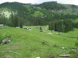
Starting from the Hotel Post, we drive through the narrow section next to the Reisinger bakery on the asphalt road along the Salzabach stream for about 5 km to the Kochalmbauer farm. Here the asphalt road ends and we continue on the gravelled forest road. We follow this up through the "Schusterin" and ignore all the turn-offs until we reach the hunting lodge "Albrechthütten" where we immediately reach the "Rechenplatz" (1008 m). Here we turn left over the bridge, climbing steadily up to the Pyrmoos and above the Salzaalm again to the left up to the highest point of the tour (1200 m). At the barrier, we turn left once more and from now on descend to the next ground, the so-called Klaushöfl.
Then we turn left downhill to the Grundlsee.
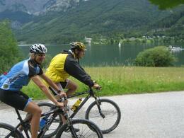
Once at the lake, we turn right towards Gößl and ride along the lake to the hamlet of Schachen. Here we enjoy the view down to the lake. From here we stay on the lakeside road and continue to the Seeklausbrücke bridge. We turn left approx. 300 m after the Seeklausbrücke and ride on the asphalt road over the Radling to Pichl-Kainisch. Once in the centre of the village, we descend to the level crossing and immediately turn left onto the >R19< in the direction of Bad MItterndorf.
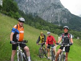
At the Jausenstation Stieger we stay on the >R19< and follow it via the small village of Obersdorf to Bad Mitterndorf.
Safety instructions:
A few more requests - the nature and wildlife will thank you and the biking experience will be an even more beautiful one:
Please note the disclaimer!
Equipment:
A few tips for safe biking:
Further information and links:
Tip: the OutdoorActive tours app, available free of charge on Google Play and in the App Store (Android, iOS) offers detailed first-hand information: short facts (length, duration, difficulty, ascent and descent in metres of altitude, ratings), map, route descriptions, altimeter, compass, summit finder, navigation along the tour. In addition, you can create your personal list of favourite tours and points, save tours and excursion destinations offline, play on social media channels and more.
Starting from the Hotel Post, we drive through the narrow section next to the Reisinger bakery on the asphalt road along the Salzabach stream for about 5 km to the Kochalmbauer farm. Here the asphalt road ends and we continue on the gravelled forest road. We follow this up through the "Schusterin" and ignore all the turn-offs until we reach the hunting lodge "Albrechthütten" where we immediately reach the "Rechenplatz" (1008 m). Here we turn left over the bridge, climbing steadily up to the Pyrmoos and above the Salzaalm again to the left up to the highest point of the tour (1200 m). At the barrier, we turn left once more and from now on descend to the next ground, the so-called Klaushöfl.
Then we turn left downhill to the Grundlsee.
Once at the lake, we turn right towards Gößl and ride along the lake to the hamlet of Schachen. Here we enjoy the view down to the lake. From here we stay on the lakeside road and continue to the Seeklausbrücke bridge. We turn left approx. 300 m after the Seeklausbrücke and ride on the asphalt road over the Radling to Pichl-Kainisch. Once in the centre of the village, we descend to the level crossing and immediately turn left onto the >R19< in the direction of Bad MItterndorf.
At the Jausenstation Stieger we stay on the >R19< and follow it via the small village of Obersdorf to Bad Mitterndorf.
Safety instructions:
A few more requests - the nature and wildlife will thank you and the biking experience will be an even more beautiful one:
- Please stay on the designated paths!
- Please stick to the "nature opening hours": April to August from 07:00 a.m. to 07:00 p.m., September from 08:00 a.m. to 06:00 p.m. and October from 09:00 a.m. to 05:00 p.m.
- Please do not leave any litter!
- Hikers and pedestrians have priority!
- Drive responsibly and in half-sightedness!
- Only ride a bike that is in perfect technical condition! Also in the sense of your health!
Please note the disclaimer!
Equipment:
A few tips for safe biking:
- Check your bike's air pressure, spoke tension and brake pads after and before every tour.
- A helmet is a must for every bike tour.
- Consider in advance what equipment you need to take with you: warm clothing, rain and wind protection, a repair kit and first aid kit belong in your rucksack, as does a charged mobile phone.
Further information and links:
Tip: the OutdoorActive tours app, available free of charge on Google Play and in the App Store (Android, iOS) offers detailed first-hand information: short facts (length, duration, difficulty, ascent and descent in metres of altitude, ratings), map, route descriptions, altimeter, compass, summit finder, navigation along the tour. In addition, you can create your personal list of favourite tours and points, save tours and excursion destinations offline, play on social media channels and more.
Starting point: Center of Bad Mitterndorf
Destination: Starting point
further information:
- Flatly
- Board possible
details mountainbike
- Riding technique: medium
April to August from 07:00 a.m. to 07:00 p.m.
September from 08:00 a.m. to 06:00 p.m.
October from 09:00 a.m. to 05:00 p.m.
Accessibility / arrival
Public Transit
Trainstation nearby: Bad Mitterndorf-Heilbrunn
Parking
In the center of Bad Mitterndorf there is parking available!
Getting there
Detailed information how to get to the Ausseerland – Salzkammergut you will find on our website!
Public Transit
Trainstation nearby: Bad Mitterndorf-Heilbrunn
ÖBB (train): www.oebb.at
Parking
In the center of Bad Mitterndorf there is parking available!
- Free entry
- Suitable for groups
- Suitable for teenagers
- Suitable for single travelers
- Suitable for friends
- Suitable for couples
- Spring
- Summer
- Autumn
Please get in touch for more information.
Bad Mitterndorf 58
8983 Bad Mitterndorf
Phone +43 3623 2444
E-Mail info.badmitterndorf@ausseerland.at
Web www.ausseerland.at
https://www.ausseerland.at
Interactive elevation profile
Create PDF
Tour-Details
Starting place: 8983 Bad Mitterndorf
Destination: 8983 Bad Mitterndorf
duration: 4h 0m
length: 41,4 km
Altitude difference (uphill): 643m
Altitude difference (downhill): 643m
Lowest point: 708m
Highest point: 1.200m
difficulty: medium
condition: medium
panoramic view: Dreamtour
Paths covering:
Asphalt, Path / trail, Gravel, Street, Hiking trail, Other
powered by TOURDATA


