Buggy-Tour Krungl


- Suitable for families
- Suitable for pushchairs
Interactive elevation profile
Create PDF
Tour-Details
Starting place: 8983 Bad Mitterndorf
Destination: 8983 Bad Mitterndorf
duration: 1h 16m
length: 5,2 km
Altitude difference (uphill): 31m
Altitude difference (downhill): 31m
Lowest point: 799m
Highest point: 830m
difficulty: very easy
condition: very easy
panoramic view: Some Views
Paths covering:
Asphalt, Gravel
powered by TOURDATA
Short description:
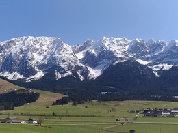
Beautiful circular tour with a beautiful view to the Grimming.
Beautiful circular tour with a beautiful view to the Grimming.
Quality of experience: *
Recommended season:
- April
- May
- June
- July
- August
- September
- October
- November
Properties:
- Family friendly
- Suitable for strollers
Partly on taramac or graveled roads there are a few nice walking routes from Krungl to Bad Mitterndorf and back. This is one of those.
Directions:
Following the hiking route number 2 you shall turn after approximately 700 meters to the left. After a small uphill you have to take the next turn to the right. After that again to the left and from than on just following the road and straight ahead over the crossroads. Afterwards you just need to carry on walking on the graveld road to the left.
By passing a few houses the routs leads in direction to the small river called "Krunglbach". There again for the way back you have to turn to the left and walk back to Krungl along the Krunglbach.
Tip:
At the hotel and restaurant "Landhotel Kanzler" you will find a nice place to rest and eat or drink something.
Safety guidelines:
It is recommendet that children have the licence for cycling.
Please note the exclusion of liability!
Equipment:
Don't forget to take also a waterproof jacket and proper clothes, for any tour you are about to do.
Starting point: "Krungl"
Destination: "Krungl"
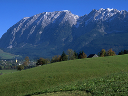
Blick zum Grimming (2351m)
Accessibility / arrival
Public Transit
Next trainstation: Tauplitz
Parking
Parking available at the starting point free of charge!
Getting there
Detailed information how to get to the Ausseerland – Salzkammergut you will find on our website!
Public Transit
Next trainstation: Tauplitz
Transport service Narzissenjet
www.ausseerland.at/narzissenjet
No transport of bicycles possible!
ÖBB (train): www.oebb.at
Verbundlinie Steiermark (bus): www.busbahnbim.at
Parking
Parking available at the starting point free of charge!
- Suitable for pushchairs
- Spring
- Summer
- Autumn
- Early winter
Please get in touch for more information.
Bad Mitterndorf 58
8983 Bad Mitterndorf
Phone +43 3623 2444
E-Mail info.badmitterndorf@ausseerland.at
Web www.ausseerland.at
http://www.ausseerland.at
Interactive elevation profile
Create PDF
Tour-Details
Starting place: 8983 Bad Mitterndorf
Destination: 8983 Bad Mitterndorf
duration: 1h 16m
length: 5,2 km
Altitude difference (uphill): 31m
Altitude difference (downhill): 31m
Lowest point: 799m
Highest point: 830m
difficulty: very easy
condition: very easy
panoramic view: Some Views
Paths covering:
Asphalt, Gravel
powered by TOURDATA


