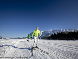
Krungl cross-country ski-track (M2)


- Suitable for families
- Multi-day tour
- Flatly
Interactive elevation profile
Create PDF
Tour-Details
Starting place: 8983 Bad Mitterndorf
Destination: 8983 Bad Mitterndorf
duration: 1h 3m
length: 4,9 km
Altitude difference (uphill): 52m
Altitude difference (downhill): 52m
Lowest point: 815m
Highest point: 850m
difficulty: very easy
condition: easy
panoramic view: Dreamtour
Paths covering:
snow
powered by TOURDATA
Trail not in operation
Short description:
The cross-country ski-track „Krungl Loipe“ is part of the more than 200 kilometers long Salzkammergut trails.
The cross-country ski-track „Krungl Loipe“ is part of the more than 200 kilometers long Salzkammergut trails.
Quality of experience: ******
Recommended season:
- January
- February
- March
- November
- December
Properties:
- Loop
- Multi-stage route
- Scenic
- Refreshment stops available
- Family friendly
because of its ascents and descents ideal for endurance training.
- The current report of the cross-country ski-tracks you will find here.
- The prices for the tickets and all the points of sales you will find on the website.
Directions:
In east direction from the parking next to the Grimminghalle this slope leads to Krungl and is connected with the other track "Kulmloipe".
Safety guidelines:
Please note the exclusion of liability!
Equipment:
Equipment for cross-country skiing necessary!
Additional information:
Trail rules
- Please run in the right lane
- Please observe and follow the running direction
- Please clear the track for faster runners
- Please respect that dogs are not allowed
- Please be careful at blind bends
- Please note that in case of an accident assistance is obligatory
- Use at one’s own risk
Pedestrians are not allowed to walk on the tracks!!
Starting point: Points of access: Hotel Grimmingblick, Gasthof Neuwirth, Landhotel Kanzler
Destination: Points of access: Hotel Grimmingblick, Gasthof Neuwirth, Landhotel Kanzler
further information:
- Multi-day tour
- Flatly
- Board possible
Details - Trail
- Nordic skiing facilities: Marked Nordic skiing run
- Type of Nordic skiing run: Classic + skating
Accessibility / arrival
Public Transit
Railway station nearby: Pichl-Kainisch
Parking
Parking free of charge at the starting point available!
Getting there
Detailed information how to get to the Ausseerland – Salzkammergut you will find on our website!
Public Transit
Railway station nearby: Pichl-Kainisch
ÖBB (train): www.oebb.at
Parking
Parking free of charge at the starting point available!
Most economical season
- Spring
- Early winter
- Deep winter
Please get in touch for more information.
Bad Mitterndorf 58
8983 Bad Mitterndorf
Phone +43 3623 2444
E-Mail info.badmitterndorf@ausseerland.at
Web www.ausseerland.at
http://www.ausseerland.at
Interactive elevation profile
Create PDF
Tour-Details
Starting place: 8983 Bad Mitterndorf
Destination: 8983 Bad Mitterndorf
duration: 1h 3m
length: 4,9 km
Altitude difference (uphill): 52m
Altitude difference (downhill): 52m
Lowest point: 815m
Highest point: 850m
difficulty: very easy
condition: easy
panoramic view: Dreamtour
Paths covering:
snow
powered by TOURDATA


