Freiberg cross-country ski-track (T1)


- Suitable for families
- Multi-day tour
- Flatly
Interactive elevation profile
Create PDF
Tour-Details
Starting place: 8982 Bad Mitterndorf
Destination: 8982 Bad Mitterndorf
duration: 1h 19m
length: 6,2 km
Altitude difference (uphill): 40m
Altitude difference (downhill): 40m
Lowest point: 935m
Highest point: 975m
difficulty: very easy
condition: easy
panoramic view: Dreamtour
Paths covering:
snow
powered by TOURDATA
Trail not in operation
Short description:
The cross-country ski-track "Freiberg Loipe" is part of the total 200 km tracks of the "Salzkammergut-Loipen".
The cross-country ski-track "Freiberg Loipe" is part of the total 200 km tracks of the "Salzkammergut-Loipen".
Quality of experience: ******
Recommended season:
- January
- February
- March
- November
- December
Properties:
- Loop
- Multi-stage route
- Scenic
- Refreshment stops available
- Family friendly
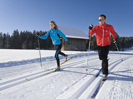
Simple track with marvelous view to the mountain "Grimming.
- Please find here the updated report of the tracks in the entire region!
Directions:
With an outstanding view to the Grimming you run in a wonderful natural landscape.
Safety guidelines:
Please note the exclusion of liability!
Equipment:
Equipment for cross-country skiing necessary!
Additional information:
Trail rules
- Please run in the right lane
- Please observe and follow the running direction
- Please clear the track for faster runners
- Please respect that dogs are not allowed
- Please be careful at blind bends
- Please note that in case of an accident assistance is obligatory
- Use at one’s own risk
Pedestrians are not allowed to walk on the tracks!!
Starting point: Tenniscourt in Tauplitz
Destination: Tenniscourt in Tauplitz
further information:
- Multi-day tour
- Flatly
- Board possible
Details - Trail
- Nordic skiing facilities: Marked Nordic skiing run
- Type of Nordic skiing run: Classic + skating
Accessibility / arrival
Public Transit
Arrival with the train (railway station in Tauplitz)
Parking
Parking available!
Getting there
Main road B 145, exit Tauplitz
Detailed information how to get to the Ausseerland – Salzkammergut you will find on our website!
Public Transit
Arrival with the train (railway station in Tauplitz)
Information at train schedule:
ÖBB: www.oebb.at
Parking
Parking available!
Most economical season
- Spring
- Early winter
- Deep winter
Please get in touch for more information.
Bad Mitterndorf 58
8983 Bad Mitterndorf
Phone +43 3623 2444
E-Mail info.badmitterndorf@ausseerland.at
Web www.ausseerland.at
http://www.ausseerland.at
Interactive elevation profile
Create PDF
Tour-Details
Starting place: 8982 Bad Mitterndorf
Destination: 8982 Bad Mitterndorf
duration: 1h 19m
length: 6,2 km
Altitude difference (uphill): 40m
Altitude difference (downhill): 40m
Lowest point: 935m
Highest point: 975m
difficulty: very easy
condition: easy
panoramic view: Dreamtour
Paths covering:
snow
powered by TOURDATA


