Via Salis


- culturally interesting
- Flatly
Interactive elevation profile
Create PDF
Tour-Details
Starting place: 8992 Altaussee
Destination: 8992 Altaussee
duration: 3h 30m
length: 10,2 km
Altitude difference (uphill): 380m
Altitude difference (downhill): 380m
Lowest point: 720m
Highest point: 1.050m
difficulty: easy
condition: medium
panoramic view: Dreamtour
Paths covering:
Asphalt, Path / trail, Gravel, Street, Hiking trail, Other
powered by TOURDATA
Short description:
This path is dedicated to the theme "SALT". In intervals of 5 to 20 minutes with 24 stations its visitor will be informed about this topic.
This path is dedicated to the theme "SALT". In intervals of 5 to 20 minutes with 24 stations its visitor will be informed about this topic.
Quality of experience: ******
Recommended season:
- April
- May
- June
- July
- August
- September
- October
Properties:
- Loop
- Scenic
- Refreshment stops available
- Cultural/historical value
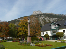
The tour leads around the small moutain "Dietrichskogel"and takes you on a journey through the years representing the origin of the saltmine in our region. 24 stations show interesting historical facts. It is an effortless and well-marked route. After 4 kilometers and an uphill of 300 meters in altitude you reach the highest point of the tour. After a downhill, which is a bit more steep finally you will get to the saltmine, which is open for the public offering guided tours. Walking time is estimated with about three hours.
Directions:
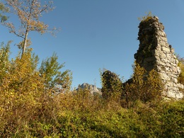
Altaussee, town hall - park - bridge "Donisbrücke" - area "Reith" - paht number 11a - castle ruin "Burgruine Pflindsberg" - meadow "Schlosswiese" - Waldgraben - path to the "Moosberg" - "Moosberg" - gallery "Ahornberg-Stollen" - gallery "Sandlingberg-Stollen" - crossing on the saddel - gallery "Breunerberg-Stollen" - forest road in direction to the skiing resort - new path to the gallery "Kriechbaumberg-Stollen" - showmine "Salzwelten" - house "Knappenhaus" - gallery "Ferdinandberg-Stollen" - station "Sole-Messstation" - gallery "Franzberg-Stollen" - path throughout the meadows - area "Thörl" - bridge "Donisbrücke" and back to the park.
Tip:
The 3 more difficult passages can be avoided by walking the forest roads, especially between station 8 and 9. For those who don't like the uphill to station 11 (Ahornsberg), they can go from the so-called "Moosberg" on the flat road straight to the "Sandlingberg".
Safety guidelines:
Please note the exclusion of liability!
Equipment:
Firm footwear, snacks and drinks for the way and also warm clothes for a visit in the saltmine are recommended.
Additional information:
Weitere Informationen
TVB Ausseerland – Salzkammergut
Tel. +43 3622 54040-0
info@ausseerland.at
www.ausseerland.at
Starting point: Town Hall in Altaussee
Destination: Town Hall in Altaussee
further information:
- Flatly
- Board possible
")
Salzwelten Altaussee
")
Via Salis Stationen 21/22
Via Salis Station 10
Via Salis Station 11
Via Salis Station 12
Via Salis Station 13
Via Salis Station 14
Via Salis Station 15
Via Salis Station 16 und 17
Via Salis Station 17
Via Salis Station 2
Via Salis Station 23
Via Salis Station 24
Via Salis Station 3
Via Salis Station 4
Via Salis Station 5
Via Salis Station 6
Via Salis Station 7
Via Salis Station 8
Via Salis Station 9
Via Salis Stationen 18/19
Via Salis, Station I
Accessibility / arrival
Public Transit
Railway station nearby: Bad Aussee
Parking
Parking directly at the starting point available. Liable to fees!
Getting there
Detailed information how to get to the Ausseerland – Salzkammergut you will find on our website!
Public Transit
Railway station nearby: Bad Aussee
ÖBB (train): www.oebb.at
Verbundlinie Steiermark (bus): www.busbahnbim.at
Public transport service Narzissenjet:
www.ausseerland.at/narzissenjet
Parking
Parking directly at the starting point available. Liable to fees!
Most economical season
- Spring
- Summer
- Autumn
Please get in touch for more information.
Fischerndorf 61
8992 Altaussee
Phone +43 3622 71643
E-Mail info.altaussee@ausseerland.at
Web www.ausseerland.at
http://www.ausseerland.at
Interactive elevation profile
Create PDF
Tour-Details
Starting place: 8992 Altaussee
Destination: 8992 Altaussee
duration: 3h 30m
length: 10,2 km
Altitude difference (uphill): 380m
Altitude difference (downhill): 380m
Lowest point: 720m
Highest point: 1.050m
difficulty: easy
condition: medium
panoramic view: Dreamtour
Paths covering:
Asphalt, Path / trail, Gravel, Street, Hiking trail, Other
powered by TOURDATA


