Lärchwald cross-country ski-track (T3)


- Suitable for families
- Multi-day tour
- Flatly
Interactive elevation profile
Create PDF
Tour-Details
Starting place: 8982 Bad Mitterndorf
Destination: 8982 Bad Mitterndorf
duration: 1h 45m
length: 6,0 km
Altitude difference (uphill): 69m
Altitude difference (downhill): 64m
Lowest point: 1.589m
Highest point: 1.647m
difficulty: easy
condition: difficult
panoramic view: Dreamtour
Paths covering:
snow
powered by TOURDATA
Trail not in operation
Short description:
The cross-country ski-track „Lärchwald Loipe“ is part of the more than 200 kilometers long Salzkammergut trails.
The cross-country ski-track „Lärchwald Loipe“ is part of the more than 200 kilometers long Salzkammergut trails.
Quality of experience: ******
Recommended season:
- January
- February
- March
- November
- December
Properties:
- Loop
- Multi-stage route
- Scenic
- Refreshment stops available
- Family friendly
- Cableway ascent/descent
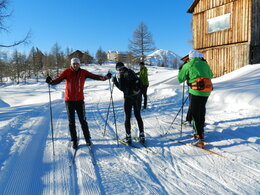
Enjoy the amazing and beautiful panorama at the 1.600 meters of altitude!
- The current report of the cross-country ski-tracks you will find here.
- The prices for the tickets and all the points of sales you will find on the website.
Directions:
This track represents a real challenge. Therefore training camps of athlets many times take place there.
Enjoy your holidays at the alpine paradise for cross country-skiing!
Safety guidelines:
Please note the exclusion of liability!
Equipment:
Equipment for cross country-skiing is necessary!
Additional information:
Trail rules
- Please run in the right lane
- Please observe and follow the running direction
- Please clear the track for faster runners
- Please respect that dogs are not allowed
- Please be careful at blind bends
- Please note that in case of an accident assistance is obligatory
- Use at one’s own risk
Pedestrians are not allowed to walk on the tracks!!
Starting point: Parking Tauplitzalm Alpenstraße
Destination: Parking Tauplitzalm Alpenstraße
further information:
- Multi-day tour
- Flatly
- Board possible
Details - Trail
- Nordic skiing facilities: Marked Nordic skiing run
- Type of Nordic skiing run: Classic + skating
Accessibility / arrival
Public Transit
Railway station nearby: Bad Mitterndorf
Parking
Parking available at the starting point!
Getting there
Detailed information how to get to the Ausseerland – Salzkammergut you will find on our website!
Public Transit
Railway station nearby: Bad Mitterndorf
ÖBB (train): www.oebb.at
Skibus to the Tauplitzalm
Parking
Parking available at the starting point!
Most economical season
- Spring
- Early winter
- Deep winter
Please get in touch for more information.
Bad Mitterndorf 58
8983 Bad Mitterndorf
Phone +43 3623 2444
E-Mail info.badmitterndorf@ausseerland.at
Web www.ausseerland.at
http://www.ausseerland.at
Interactive elevation profile
Create PDF
Tour-Details
Starting place: 8982 Bad Mitterndorf
Destination: 8982 Bad Mitterndorf
duration: 1h 45m
length: 6,0 km
Altitude difference (uphill): 69m
Altitude difference (downhill): 64m
Lowest point: 1.589m
Highest point: 1.647m
difficulty: easy
condition: difficult
panoramic view: Dreamtour
Paths covering:
snow
powered by TOURDATA


