From Lupitsch to Altaussee


Interactive elevation profile
Create PDF
Tour-Details
Starting place: 8992 Altaussee
Destination: 8992 Altaussee
duration: 1h 15m
length: 5,2 km
Altitude difference (uphill): 100m
Altitude difference (downhill): 280m
Lowest point: 708m
Highest point: 923m
difficulty: very easy
condition: very easy
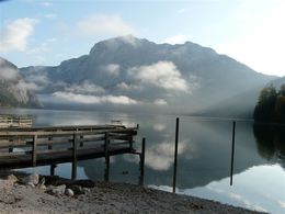
panoramic view: Some Views
Paths covering:
Asphalt, Gravel, Street
powered by TOURDATA
Short description:
A short version from the tour starting in St. Agatha to Altaussee. This route leads via the area "Lupitsch" on taramac roads to Altaussee.
A short version from the tour starting in St. Agatha to Altaussee. This route leads via the area "Lupitsch" on taramac roads to Altaussee.
Quality of experience: ***
Recommended season:
- January
- February
- March
- April
- May
- June
- July
- August
- September
- October
- November
- December
Properties:
- Refreshment stops available
Directions:
From the starting point to the right downwards and via a forest to the main road. Just before the asphaltic road the way leads you downwards to the former restaurant "Bachwirt", left over a bridge and upwards to the are "Lichtersberg". After a part in the forest (attention traffic) the road takes you downwards to the area "Rambühel". From then on you have to turn a the crossing to the right, passing the restaurant "Postillion" and then downwards to the former restaurant "Gasthof Scheichlmühle". There you have to turn to the left and follow the road until the beginning of the lake.
Tip:
Taking a ride on a horse on approved forest roads and paths is allowed from 08.30 a.m until two hours before dusk. Feeding areas and raised stands shall be avoided to be passed.
In wintertime horse riding is not allowed on roads which are not cleaned from the snow.
Only with a valied badge rides are allowed.
Anual fee: € 100,00
Weekly fee: € 10,00
This is available by the following persons:
Walter Hillbrand, +43 664 64 60 387, Bad Aussee
Karin Ceipek, +43 664 58 03 503, Bad Mitterndorf
Safety guidelines:
Please note the exclusion of liability!
Starting point: Lupitsch/Leislingstraße
Destination: Altaussee
further information:
- Board possible
Details riding
Accessibility / arrival
Parking
Parking available near the starting point!
Getting there
Detailed information how to get to the Ausseerland – Salzkammergut you will find on our website!
Parking
Parking available near the starting point!
Most economical season
- Spring
- Summer
- Autumn
- Early winter
- Deep winter
Please get in touch for more information.
Fischerndorf 61
8992 Altaussee
Phone +43 3622 71643
E-Mail info.altaussee@ausseerland.at
Web www.ausseerland.at
http://www.ausseerland.at
Interactive elevation profile
Create PDF
Tour-Details
Starting place: 8992 Altaussee
Destination: 8992 Altaussee
duration: 1h 15m
length: 5,2 km
Altitude difference (uphill): 100m
Altitude difference (downhill): 280m
Lowest point: 708m
Highest point: 923m
difficulty: very easy
condition: very easy
panoramic view: Some Views
Paths covering:
Asphalt, Gravel, Street
powered by TOURDATA


