horse riding way - Kugelberg


- All weather
- Flatly
Interactive elevation profile
Create PDF
Tour-Details
Starting place: 5324 Faistenau
Destination: 5324 Faistenau
duration: 0h 24m
length: 4,0 km
Altitude difference (uphill): 50m
Altitude difference (downhill): 50m
Lowest point: 736m
Highest point: 786m
difficulty: easy
condition: easy
panoramic view: Individual Views
Paths covering:
Asphalt, Path / trail, Gravel, Street, Hiking trail
powered by TOURDATA
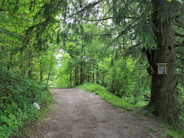
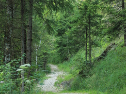
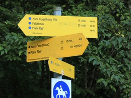
From the village square over the Bramsaustraße to the Kugelberg. Take the left way which is wider. On the half way you have two options: 1st go left in direction to Vordersee and take the way from the Vordersee round to come back to Faistenau. Or 2nd go down right in direction to treatment plant afterwards right again next to “Almbachstraße” pass the “Felsenbad”. On your right handside you’ll see an sign which brings you back to the former Bramsaubräu restaurant.
further information:
- Flatly
Details riding
- Area: easy
- Good riding experience: easy
- Feeding possible for horses
- Housing possibility for horses
- Accommodations for riders
Parking
- Parking space: 50
- Parking area for disabled: 4
- Bus parking space: 1
- All weather
- Spring
- Summer
- Autumn
- Early winter
- Deep winter
Please get in touch for more information.
Am Lindenplatz 1
5324 Faistenau
Phone +43 6226 8384 - 41
E-Mail faistenau@fuschlseeregion.com
Web www.fuschlseeregion.com
http://www.fuschlseeregion.com
Interactive elevation profile
Create PDF
Tour-Details
Starting place: 5324 Faistenau
Destination: 5324 Faistenau
duration: 0h 24m
length: 4,0 km
Altitude difference (uphill): 50m
Altitude difference (downhill): 50m
Lowest point: 736m
Highest point: 786m
difficulty: easy
condition: easy
panoramic view: Individual Views
Paths covering:
Asphalt, Path / trail, Gravel, Street, Hiking trail
powered by TOURDATA


