Von Ebensee zum Vorderen Signalkogel


Interactive elevation profile
Create PDF
Tour-Details
Starting place: 4802 Ebensee
Destination: 4802 Ebensee
duration: 2h 41m
length: 25,1 km
Altitude difference (uphill): 951m
Altitude difference (downhill): 945m
Lowest point: 432m
Highest point: 941m
difficulty: medium
condition: medium
panoramic view: Individual Views
Paths covering:
Gravel
powered by TOURDATA
The first 4.4 kilometres on the Langbathsee district road are for driving in. Then, shortly before the "Wehrerstube" hunting lodge, turn left onto the forest road with the signpost "Bledistraße". After a short, steep ascent, the road crosses the path from the "In der Kreh" country inn to the Feuerkogel. After a flat descent, turn off to the Langbathsee district road, which you follow for around 100 metres back to the "Jagerbachlstube" forester's lodge. (As an alternative, you can also cycle all the way from Ebensee Rathaus to Jagerbachlstube on the tarmac Langbathsee district road).
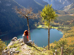
At first, you cycle on the forest road next to the Jageralmbach stream, which you cross after a short time on the right over a bridge. The road climbs steadily through a shady beech forest. At the next junction, turn left and later reach a crossroads where there is a game feeding station on the left (if you want to continue the tour towards Gh. Windlegern or Hochsteinalm then have to return from the Signalkogel to this junction). Here you have to follow the road straight ahead, which eventually leads to the foot of the Vorderer Signalkogel. Leave your bike there and walk the few metres to the scenic viewing point with a view of the Vorderer Langbathsee.
Then it's about 1.5 kilometres along the forest road back down into the valley until you come to a junction on the right at an acute angle that takes you to the Jageralm. There we follow the course of the stream on the left-hand side, whose forest road takes us back to the Jagerbachlstube. For a worthwhile detour to the Vorderer Langbathsee, add another 1.5 kilometres. If you don't take this option, you can cycle a good 6 kilometres along the Langbathsee district road to the starting point of the tour
Most economical season
- Summer
Please get in touch for more information.
4802 Ebensee
Phone +43 6133 8016
Fax machine +43 6133 8016 - 870
E-Mail ebensee@traunsee-almtal.at
Web www.traunsee-almtal.at/ebensee
http://www.traunsee-almtal.at/ebensee
Interactive elevation profile
Create PDF
Tour-Details
Starting place: 4802 Ebensee
Destination: 4802 Ebensee
duration: 2h 41m
length: 25,1 km
Altitude difference (uphill): 951m
Altitude difference (downhill): 945m
Lowest point: 432m
Highest point: 941m
difficulty: medium
condition: medium
panoramic view: Individual Views
Paths covering:
Gravel
powered by TOURDATA


