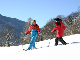
Snow shoe hiking path to the Forsthaus Wartenfels


- Flatly
Interactive elevation profile
Create PDF
Tour-Details
Path number: 10
Starting place: 5330 Fuschl am See
Destination: 5330 Fuschl am See
duration: 1h 0m
length: 3,0 km
Altitude difference (uphill): 254m
Lowest point: 670m
Highest point: 924m
difficulty: medium
condition: medium
panoramic view: Great panorama
Paths covering:
snow, Gravel, Hiking trail
powered by TOURDATA
Discover Fuschl am See in a smooth way!
The snow shoe hiking path starts at the idyllic lakeside promenade of Fuschl am See, at the path in the direction to the Waldhofalm.Follow the path through the woods and aftert about 15 minutes you will arive at the Waldhofalm where you can have your 1st break.
Then you have to follow the path number 10 (Schober, Frauenkopf). On this path you have already the possibility to have some marvellous views to the peak of the Schober. After a few minutes you will arrive at the Forsthaus Wartenfels, also a snack point.
From the Forsthaus Wartenfels you have another 30 minutes hike until you arrive at the Ruine Wartenfels. The "castle" Wartenfels was built in 1259, from there you have a marvellous view to Thalgau and on some days also farer!
Accessibility / arrival
Exit Thalgau - Road B158
Car parks in the centre of Fuschl am See.
Most economical season
- Early winter
- Deep winter
Please get in touch for more information.
")
5330 Fuschl am See
Phone +43 6226 8250
Fax machine +43 6226 8650
E-Mail fuschl@fuschlseeregion.com
Web www.fuschlseeregion.com
http://www.fuschlseeregion.com
Interactive elevation profile
Create PDF
Tour-Details
Path number: 10
Starting place: 5330 Fuschl am See
Destination: 5330 Fuschl am See
duration: 1h 0m
length: 3,0 km
Altitude difference (uphill): 254m
Lowest point: 670m
Highest point: 924m
difficulty: medium
condition: medium
panoramic view: Great panorama
Paths covering:
snow, Gravel, Hiking trail
powered by TOURDATA


