Vom Almsee über den Sepp-Huber-Steig zur Pühringerhütte


- Flatly
Interactive elevation profile
Create PDF
Tour-Details
Paths covering:
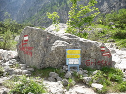
The Sepp-Huber-Steig, secured with wire ropes, leads along a steep path, but directly over the Röllsattel to the Pühringerhütte.
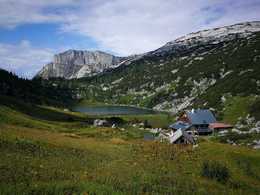
From the Almsee, hike along a forest road to the Sepp-Huber-Steig/Grieskarsteig fork. From there, follow the W214 Sepp-Huber-Steig to the foundation walls and continue along the secured path steeply up to the Röllsattel. Then over cart fields towards the south-west to the Geiernest, a striking rock face. There you meet the Ausseer Weg, which leads in a south-westerly direction to the Pühringer Hütte.
You should allow approx. 4 hours for the 1,000 metres of ascent from the Almsee.
How to get to the Almtal (to Grünau):
We recommend that you travel by public transport!
by train: from Wels station with the Almtalbahn (line 153) to Grünau im Almtal;
Numerous connections from Wels station to the main trains on the western railway line (line 101)
by bus: OÖVV bus line 533 Almsee - Grünau - Gmunden
Bus train information
Call the Traunstein Taxi Route 60 from Grünau station to Almsee GH Seehaus stop, at least 1 hour in advance at the telephone number 050-422 1691 at the taxi center or order on the otaxi app.
walking:
From the center or the train station of Grünau im Almtal you can comfortably walk along the Almuferweg "Genuss am Almfluss" via the Cumberland Wildpark to the lake Almsee!
by car:
Westautobahn A1: Vienna - Voralpenkreuz-A9 - exit Ried / Tr. - Voitsdorf - Pettenbach - Scharnstein - Grünau
Westautobahn A1: Munich - Salzburg - Regau - Gmunden - Scharnstein - Grünau
Inntal Autobahn A8 Passau - Wels - Voralpenkreuz A9 - exit Ried / Tr. - Voitsdorf - Pettenbach - Scharnstein - Grünau
From the center of Grünau, follow the country road to Almsee (15 km).
The nearest airports are Linz-Hörsching, 55 km and Salzburg, 80 km
- Suitable for groups
- Suitable for single travelers
- Suitable for friends
- Suitable for couples
- Summer
Please get in touch for more information.
4645 Grünau im Almtal
Phone +43 7616 8268
Fax machine +43 7616 8895
E-Mail almtal@traunsee-almtal.at
Web traunsee-almtal.salzkammergut.at/
Web www.puehringerhuette.at/
http://www.puehringerhuette.at/
Interactive elevation profile
Create PDF
Tour-Details
Paths covering:


