Distance hiking trail - Postalm


Interactive elevation profile
Create PDF
Tour-Details
Starting place: 5324 Hintersee
Destination: 5350 Strobl
duration: 5h 0m
length: 12,0 km
Altitude difference (uphill): 750m
difficulty: medium
condition: medium
panoramic view: Great panorama
Paths covering:
Hiking trail
powered by TOURDATA
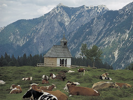
Hiking trail over the summit to the 3 Postalm alpine plateau Guided hiking tour:
We drive with a minibus to Genneralm near the village Hintersee.
From there, we start the hiking tour to the mountain Hoher Zinken and the mountain Osterhorn.
Then to the mountain Pitscherberg and Pitscherbergalm to hiking plateau Postalm.
From the park car, no 3 (near Postalm chapel) the minibus picks us up again and it goes back to the Lake Wolfgangsee.
Starting point: Genneralm
Destination: Postalm
Accessibility / arrival
From the Lake Wolfgangsee with a minibus to Genneralm near the village Hintersee.
Parking- Parking space: 15
- Suitable for groups
- Suitable for friends
- Suitable for couples
- Spring
- Summer
- Autumn
Please get in touch for more information.
Moosgasse 275
5350 Strobl
Phone +43 6137 7255
Fax machine +43 6137 5958
E-Mail office@wolfgangsee.at
Web www.wolfgangsee.at
http://www.wolfgangsee.at
Interactive elevation profile
Create PDF
Tour-Details
Starting place: 5324 Hintersee
Destination: 5350 Strobl
duration: 5h 0m
length: 12,0 km
Altitude difference (uphill): 750m
difficulty: medium
condition: medium
panoramic view: Great panorama
Paths covering:
Hiking trail
powered by TOURDATA


