Round Walk Rettenbachklamm - Karstquelle Hubhanslau


- pets allowed
- Suitable for families
- Flatly
Interactive elevation profile
Create PDF
Tour-Details
Path number: 5
Starting place: 4820 Bad Ischl
Destination: 4820 Bad Ischl
duration: 2h 0m
length: 5,8 km
difficulty: easy
condition: easy
panoramic view: Some Views
Paths covering:
Asphalt, Gravel, Hiking trail
powered by TOURDATA
Distance: 5.8 km (4.5 km without Rettenbachklamm)
Walking time: 2 hours (1 hour 30 minutes without Rettenbachklamm)
Difference in altitude: 120 m ascent, descent 120 m
Trail conditions: partly asphalt, some gravel, forest paths , several steps.
In weather, the path with the steps by Rettenbachalm is very slippery. Path closed in icy conditions
This varied hike, starts by crossing the River Traun on the Kreuzersteg and follows the river downstream before passing under the railway line to Kochstraße. This goes uphill to Dr-Sterz-Straße to a hillock with a natural wooded area called Sterzens Abendsitz. Walk straight ahead downhill to Rosenkrangasse (Bus Stop)
To reduce the trail by half an hour take the path left.
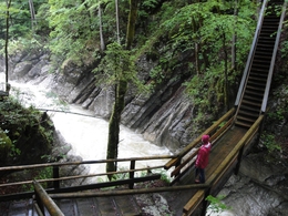
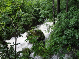
For the main trail briefly follow the wider road to the right before reaching a large signboard. Leave this access road before the first houses on the left and enter for a large meadow and walk straight towards the forest. After a few metres, the path leads to the left descending into the Rettenbachklamm. Cross the gorge on a small bridge. Beneath the bridge the water forces through the gorge. The path ascends until it reaches the road to Rettenbachalm. Follow to the left out of the valley towards the bridge on the Rettenbach. Just before the bridge the trail leads to narrow steps on the right up to a large meadow. At the end of the steps, follow to the right soon reaching the Karst spring. In several places, water wells up from the forest floor. This natural spectacle is particularly impressive after rainfall as the raging creek seems to arise out of virtually nowhere. The path continues to Rettenbach. The path goes back and forth so watch for the yellow signs. After a descent to Rettenbach cross the stream on the footbridge, climb to the right and follow the path straight ahead to the centre of Bad Ischl.
Walking time: 2 hours (1 hour 30 minutes without Rettenbachklamm)
Difference in altitude: 120 m ascent, descent 120 m
Trail conditions: partly asphalt, some gravel, forest paths , several steps.
In weather, the path with the steps by Rettenbachalm is very slippery. Path closed in icy conditions
This varied hike, starts by crossing the River Traun on the Kreuzersteg and follows the river downstream before passing under the railway line to Kochstraße. This goes uphill to Dr-Sterz-Straße to a hillock with a natural wooded area called Sterzens Abendsitz. Walk straight ahead downhill to Rosenkrangasse (Bus Stop)
To reduce the trail by half an hour take the path left.
For the main trail briefly follow the wider road to the right before reaching a large signboard. Leave this access road before the first houses on the left and enter for a large meadow and walk straight towards the forest. After a few metres, the path leads to the left descending into the Rettenbachklamm. Cross the gorge on a small bridge. Beneath the bridge the water forces through the gorge. The path ascends until it reaches the road to Rettenbachalm. Follow to the left out of the valley towards the bridge on the Rettenbach. Just before the bridge the trail leads to narrow steps on the right up to a large meadow. At the end of the steps, follow to the right soon reaching the Karst spring. In several places, water wells up from the forest floor. This natural spectacle is particularly impressive after rainfall as the raging creek seems to arise out of virtually nowhere. The path continues to Rettenbach. The path goes back and forth so watch for the yellow signs. After a descent to Rettenbach cross the stream on the footbridge, climb to the right and follow the path straight ahead to the centre of Bad Ischl.
- Suitable for groups
- Suitable for schools
- Pets allowed
- Spring
- Summer
- Autumn
Please get in touch for more information.
")
4820 Bad Ischl
Phone +43 6132 27757
E-Mail office@badischl.at
Web www.badischl.at
http://www.badischl.at
Interactive elevation profile
Create PDF
Tour-Details
Path number: 5
Starting place: 4820 Bad Ischl
Destination: 4820 Bad Ischl
duration: 2h 0m
length: 5,8 km
difficulty: easy
condition: easy
panoramic view: Some Views
Paths covering:
Asphalt, Gravel, Hiking trail
powered by TOURDATA


