Skitour auf das Spitzplaneck


Interactive elevation profile
Create PDF
Tour-Details
Starting place: 4645 Grünau im Almtal
Destination: 4645 Grünau im Almtal
duration: 6h 47m
length: 14,4 km
Altitude difference (uphill): 1.109m
Altitude difference (downhill): 1.105m
Lowest point: 582m
Highest point: 1.587m
difficulty: easy
condition: easy
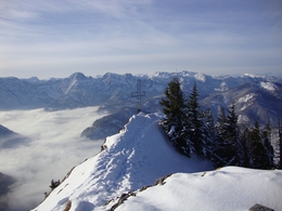
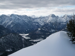
panoramic view: Some Views
Paths covering:
snow
powered by TOURDATA
The summit cross on the Spitzplaneck stands lonely, not far from the mountain station of the Kasbergalm drag lift.
Nice ski tour partly along the slopes and in open terrain, crampons advisable in hard snow on sections.
Hardly any risk of avalanches
If there is just enough snow away from the snow-covered slopes to cover rocks and roots, ski tours with going back downhill on the regular skislopes are a good alternative.
However, there are some rules to be observed! Skiers have priority and you should only climb uphill at the edge of the slope and one behind the other. When climbing to the Spitzplaneck summit, you can use the area of the Kasberg ski resort, parta of the ascent also lead over open touring area.
The starting point of this ski route is the basestation of the Kasbergbahn cable car. Along the so called "Talabfahrt" ski run, you climb uphill.
On some steeper slopes, crampons provide energy-saving support and safety. A good variant is to climb the flatter family skirun to the "Hochberghaus" hut. This is where the ascent joins, which, depending on the snow conditions, leads up along the marked summer path directly from the village centre of Grünau.
You pass the cable car and climb comfortably higher. At an altitude of 1290 meters, you leave the slope and turn onto the ridge of the "Benn-Nock" mountain. Once at the summit, after a short glide down through the light mountain forest, you can return to the slope area. You can easily make your mark the last stretch up to the mountain station of the Kasbergalm tow lift. You reach the short summit slope to the Spitzplaneck through a small depression. Wind and snow have left their marks on the cross and you hardly believe you are so close to civilization.
For the descent, you cross into the ski area and on the slopes you swing back down into the valley.
Most economical season
- Spring
- Early winter
- Deep winter
Please get in touch for more information.
4645 Grünau im Almtal
Phone +43 7616 7085
mobile +43 7616 8268
E-Mail almtal@traunsee-almtal.at
Web www.kasberg.at
Web traunsee-almtal.salzkammergut.at
http://www.kasberg.at
https://traunsee-almtal.salzkammergut.at
https://traunsee-almtal.salzkammergut.at
")
")
")
")
Interactive elevation profile
Create PDF
Tour-Details
Starting place: 4645 Grünau im Almtal
Destination: 4645 Grünau im Almtal
duration: 6h 47m
length: 14,4 km
Altitude difference (uphill): 1.109m
Altitude difference (downhill): 1.105m
Lowest point: 582m
Highest point: 1.587m
difficulty: easy
condition: easy
panoramic view: Some Views
Paths covering:
snow
powered by TOURDATA


