Pinsdorf - Almsee


Interactive elevation profile
Create PDF
Tour-Details
Starting place: 4812 Pinsdorf
Destination: 4812 Pinsdorf
duration: 2h 45m
length: 36,7 km
Altitude difference (uphill): 466m
Altitude difference (downhill): 371m
Lowest point: 429m
Highest point: 623m
difficulty: easy
condition: easy
panoramic view: Some Views
Paths covering:
Asphalt, Street, Other
powered by TOURDATA
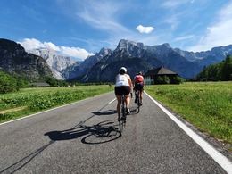
This beautiful road bike tour starts in Pinsdorf, from where we cycle slightly downhill before tackling the climb up to St. Konrad. From there we continue eastwards to Scharnstein / Mühldorf, from here we cycle along the Alm, always slightly uphill, southwards via Grünau to the Almsee. From there we cycle the same route back to the starting point.
Most economical season
- Summer
Please get in touch for more information.
4812 Pinsdorf
Phone +43 7612 639 - 55
E-Mail gemeinde@pinsdorf.ooe.gv.at
Web www.pinsdorf.at/
https://www.pinsdorf.at/
Interactive elevation profile
Create PDF
Tour-Details
Starting place: 4812 Pinsdorf
Destination: 4812 Pinsdorf
duration: 2h 45m
length: 36,7 km
Altitude difference (uphill): 466m
Altitude difference (downhill): 371m
Lowest point: 429m
Highest point: 623m
difficulty: easy
condition: easy
panoramic view: Some Views
Paths covering:
Asphalt, Street, Other
powered by TOURDATA


