TASSILO via ferrata on the Schermberg mountain - Grünau im Almtal


Interactive elevation profile
Create PDF
Tour-Details
Paths covering:
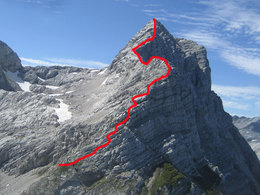
With a length of 1400 meters and almost 600 meters of altitude, this via ferrata challenges other ridge via ferrata classics.
The former tourism association Almtal and the Alpine Club Section Wels created new incentives for alpine athletes with the Tassilo via ferrata C / D and three new practice via ferratas in difficulty levels A, C, D.
The official handover to the project initiators took place in August 2009.
Although demanding, the tour is also for connoisseurs. Named after the historical Bavarian Duke Tassilo III, founder of the Kremsmünster monastery, the Tassilo via ferrata opens up the mountain world of the Dead Mountains to the mountaineer: deep down into the Hetzau valley and a distant view to the Bohemian Forest, the Dachstein, the main Alpine ridge and over the bare, seemingly endless Limestone plateau between Groß Priel, Spitzmauer, Temelberg and Rotgschirr. The Dead Mountains also owes its reputation to this high plateau with its numerous sinkholes, karen and shafts, making it an insider tip for mountaineers and nature lovers.
For this scenic and challenging alpine tour, nine to ten hours of pure walking time have to be planned, during which a total of 1700 vertical meters have to be mastered. Experience, good physical condition and safe weather are essential.
Here the two shelters are welcome bases. Right at the beginning, the path leads past the Almtalerhaus through the largest landslide valley in Europe, the Hetzau Valley, which ends suddenly at the 1400 m towering Schermberg north face. It is the second highest in the Eastern Alps after the Watzmann east face and is famous for its climbing routes.
With the north wall always in view, the path quickly becomes steeper up to the Welser hut. From there it is only 30 minutes to the via ferrata in a cave-like niche.
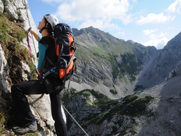
The climb is on level C / D with three strong D-digits that are vertical and about five to eight meters high. The first striking stop on the tour is the summit of the Almtaler Köpfl at 2,205 m. Then we continue over very impressive airy ridges to the summit of the Schermberg, 2,396 m, where the climb ends.
Equipment: Complete via ferrata equipment and helmet
further information:
- Board possible
Details - climbing mount
- difficulty acc. to Kurt Schall: very difficult (D)
- Hop off description: This long alpine via ferrata in beautiful limestone rock has a few difficult individual points. It runs mostly along the exposed ridge with breathtaking deep views into the famous Schermberg mountain north face. The "Tassilo" is one of the longest climbing systems in Europe and impresses with its varied and modern climbing guidance, which requires only a few climbing aids. Difficulty Moderately difficult but long, mostly A and B to C, with three short and powerful D passages. Exposition: On the east side of the Schermberg mountain, mostly south to east. Fuses: steel cable, kick bars Starting point Grünau im Almtal - "Almtaler Haus" mountain hut (714 m) Ascent to "Welser Hütte" mountain hut (1726 m) in 3 hours From the "Welser Hütte" mountain hut in 30 minutes (100 m) to Entry at the pond Climb length approx. 1,400 m Difference in altitude 600 m via ferrata Climbing time approx. 3 hours Not suitable for children; suitable for young people with experience and in very good condition.
- Hop on description: Descent: Via Hermann-Wöhs-Steig (No. 265) in approx. 1 hour to the"Welser Hütte" mountain hut Path No. 263 and Ausseer Weg (No. 215) to the Fleischbanksattel and from there to the "Welser Hütte" mountain hut Transition path no.263 and on Ausseer Weg (no.215) to Temlbergsattel, then on path no.201 through the Klinser Schlucht to the "Prielschutzhaus" mountain hut Demolitions: yes, in the area of the Almtaler Köpfel
- duration hop on: 3 h
- duration climbing mount: 3 h
- duration Descent: 1 h
May, June, July, August
We recommend that you travel by public transport!
Bus-train information
By train: Arrival with the Almtalbahn 153 from Wels.
by bus: OÖVV bus line 533 Gmunden - Scharnstein - Grünau im Almtal - Almsee
with the Traunstein taxi:
Route 60 from the railway station to all sights in Grünau im Almtal.
Call the taxi office 1 hour in advance on 050-422 1691 or order on the otaxi app.
by bike: on the R 11 from Wels to Grünau im Almtal
by car:
Motorway A1: Leave the Westautobahn A1 in Regau and follow the B145 to Scharnstein and Grünau im Almtal.
A9 motorway: Leave the A9 in Inzersdorf-Kirchdorf and follow the Austrian Romanikstraße to Scharnstein and Grünau im Almtal.
Please only use the parking spaces provided and be considerate of private property! Thank you for your fairness!
With the Traunstein Taxi Route 60 from the station Grünau to the Almtalerhaus, call at least 1 hour in advance at the telephone number 050-422 1691 or order from the otaxi app.
Outside the times of the Traunstein taxi, we recommend
Taxi Redl +43 664 2301910
on request
- Suitable for single travelers
- Suitable for couples
- Summer
Please get in touch for more information.
4645 Grünau im Almtal
Phone +43 7616 8268
Fax machine +43 7616 8895
E-Mail almtal@traunsee-almtal.at
Web www.traunsee-almtal.at
Web www.via-ferrata.de/klettersteige/to…
https://www.via-ferrata.de/klettersteige/topo/tassilo-klettersteig-am-schermberg
Interactive elevation profile
Create PDF
Tour-Details
Paths covering:


