Place "Vogl Anna Platzl" way


- Suitable for families
Interactive elevation profile
Create PDF
Tour-Details
Starting place: 4880 St. Georgen im Attergau
Destination: 4880 St. Georgen im Attergau
duration: 1h 0m
length: 3,0 km
Altitude difference (uphill): 35m
difficulty: easy
condition: easy
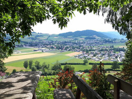
panoramic view: Great panorama
Paths covering:
Asphalt, Hiking trail
powered by TOURDATA
On the mountain "Koglberg" you can see all 3 local authorities Berg, Straß and St. Georgen im Attergau.
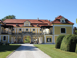
Please hike from the church St. Georgen im Attergau the hill along to an old bridge, which guides you over the river "Dürre Ager". If you go right you are at the street Kottulinskystraße and hold on at the cross. Take the left way in direction to Schloßweg. The allee will guide you directly to Schloss Kogl. Go left along the castle and hike along the street Weißenkrichener Bundesstraße. After 50 meters on the left side is a sign in the direction to "Koglberg". Follow the sign until Celtic Tree Path (Keltenbaumweg), the station is called "Insel der Sinne". At this point the place "Vogl-Anna-Platzl isn't far away. A part of this route is in forest, so this way is possible for all weather.
SPECIAL POINS:
Place: Vogl-Anna-Platzl
Starting point: Parish church St. Georgen im Attergau
Destination: Vogl Anna Place at the Koglberg
Accessibility / arrival
By car:
From Salzburg via motorway A1 – Exit St. Georgen im Attergau – right on the Attergaustraße
(L540) to the center.
From Vienna/Linz via motorway A1 – Exit St. Georgen im Attergau – right on the
Attergaustraße (L540) to the center.
From Bad Ischl – Weißenbachtal (B153) – follow B152 to Unterach and then B151 to
Attersee than left to the Attergaustraße (L540) to St. Georgen.
By train:
From Salzburg or Linz/Vienna with „Austrian Federal Railways“ or „Westbahn“ to Attnang
Puchheim - via regional train to Vöcklamarkt and St. Georgen
By plane:
Arrival to Airport Salzburg or Linz – with the car/bus or train to St. Georgen im Attergau.
- Parking space: 20
- Suitable for teenagers
- Suitable for seniors
- Suitable for single travelers
- Suitable for friends
- Suitable for couples
- Suitable for children
- Spring
- Summer
- Autumn
- Early winter
Please get in touch for more information.
Attergaustraße 55
4880 St. Georgen im Attergau
Phone +43 7667 7719 - 80
E-Mail info.attergau@attersee.at
Web attersee-attergau.salzkammergut.at
https://attersee-attergau.salzkammergut.at
You can also visit us on
Visit us on Facebook Visit us on Instagram Visit us on Pinterest Visit our videochannel on YouTube WikipediaInteractive elevation profile
Create PDF
Tour-Details
Starting place: 4880 St. Georgen im Attergau
Destination: 4880 St. Georgen im Attergau
duration: 1h 0m
length: 3,0 km
Altitude difference (uphill): 35m
difficulty: easy
condition: easy
panoramic view: Great panorama
Paths covering:
Asphalt, Hiking trail
powered by TOURDATA


