Rosskopf (1657 m) - Hainzen (1638 m)


- Suitable for families
Interactive elevation profile
Create PDF
Tour-Details
Starting place: 4820 Bad Ischl
Destination: 4820 Bad Ischl
duration: 5h 48m
length: 7,8 km
Altitude difference (uphill): 1.308m
Altitude difference (downhill): 408m
Lowest point: 516m
Highest point: 1.617m
difficulty: medium
condition: medium
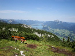
panoramic view: Dreamtour
Paths covering:
Hiking trail
powered by TOURDATA
From Gasthof zur Wacht to the mountain station of the Katrinseilbahn (cable car)
Walking time: 4 hours ascent - descent 1 hour (To reach the valley on foot requires a further
1 hour 30 minutes)
Difference in altitude: 1300 m ascent, descent 300 m
Requirements: long and strenuous, sometimes quite challenging
hike with great views during the transition from Roßkopf to Katrinalm. Sure-footedness is vital!
Variations: From the Roßkopf there are several routes to reach the Katrinalm
The trail begins from the signpost by the small bridge to the left of the Gasthof zur Wacht. Follow the road along the stream for 400 m to a farm going to the left. Before crossing the stream again,
at a signpost with multiple signs, leave the road to the left. It is now about 1 hour uphill, through the forest, to a signpost (47 ° 41'31 "N - 013 ° 32'39 " E - 1010m). The forest track is crossed three times. The trail becomes steeper and passes a hunting lodge. After a further 1 hour of walking you reach the Ahornfeld meadow with a beautiful view Lake Wolfgang. (The alm hut is not open). From here it is not far to the summit of Roßkopf (47 ° 40'57 "N - 013 ° 33'12 " E - 1657 m). Descending, for 15 minutes you reach a signpost (47 ° 41'01 "N - 013 ° 33'28 " E - 1550 m). From here there are 2 options, both of similar distance. The right route is beautiful but those afraid of heights should choose the left route. The trail rises and falls reaching the summit of Hainzen in 35 minutes (47 ° 41'13 "N - 013 ° 34'00 " E - 1638 m). After another 15 minutes, the trail reaches an intersection (47 ° 41'20 "N - 013 ° 34'15 " E - 1610 m). Those feeling strong enough can take the left route for a 30 minute longer variant to Elferkogel (1601 m) the Katrin Cross ( 1542 m) and to Katrinalm. Otherwise take the right route which rises and after 20 minutes reaches another intersection again keep to the right for 50 minutes to reach the mountain station of Katrinseilbahn (cable car) If the cable car is not running, the walk down to the valley will take another 1 hour and 30 minutes.
Starting point: Gasthof zur Wacht ( 47 ° 42'39 "N - 013 ° 32'55 " E - 520 m) , parking . Directions: From Bad Ischl on the B 158 about 5 km towards Salzburg. The Gasthof zur Wacht is located at the end of a long straight section of road, on the left hand side. The starting point can also be reached by public transport.
Destination: mountain station of the Katrinseilbahn (cable car) (47 ° 41'09 "N - 013 ° 34'58 " E- 1415 m). Caution: The cable car runs from May to October Walking time: 4 hours ascent - descent 1 hour (To reach the valley on foot requires a further 1 hour 30 minutes)
- Suitable for friends
- Suitable for couples
- Summer
- Autumn
Please get in touch for more information.
4820 Bad Ischl
Phone +43 6132 27757
Fax machine +43 6132 27757 - 77
E-Mail office@badischl.at
Web www.badischl.at
http://www.badischl.at
Interactive elevation profile
Create PDF
Tour-Details
Starting place: 4820 Bad Ischl
Destination: 4820 Bad Ischl
duration: 5h 48m
length: 7,8 km
Altitude difference (uphill): 1.308m
Altitude difference (downhill): 408m
Lowest point: 516m
Highest point: 1.617m
difficulty: medium
condition: medium
panoramic view: Dreamtour
Paths covering:
Hiking trail
powered by TOURDATA


