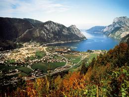
Ebenseer Soleleitungsweg


Interactive elevation profile
Create PDF
Tour-Details
Starting place: 4802 Ebensee
Destination: 4802 Ebensee
duration: 5h 9m
length: 18,8 km
Altitude difference (uphill): 308m
Altitude difference (downhill): 268m
Lowest point: 430m
Highest point: 512m
difficulty: easy
condition: medium
panoramic view: Some Views
Paths covering:
Asphalt
powered by TOURDATA
In the footsteps of the salt!
Starting point: Heimathaus Ebensee
Destination: central district of Ebensee

Accessibility / arrival
from the highway: departure Regau-B 145 in the direction of Bad Ischl-turn into the center of Ebensee
- Suitable for groups
- Suitable for schools
- Spring
- Summer
- Autumn
Please get in touch for more information.
4802 Ebensee
Phone +43 6133 8016
E-Mail ebensee@traunsee-almtal.at
Web www.traunsee-almtal.at/ebensee
http://www.traunsee-almtal.at/ebensee
Interactive elevation profile
Create PDF
Tour-Details
Starting place: 4802 Ebensee
Destination: 4802 Ebensee
duration: 5h 9m
length: 18,8 km
Altitude difference (uphill): 308m
Altitude difference (downhill): 268m
Lowest point: 430m
Highest point: 512m
difficulty: easy
condition: medium
panoramic view: Some Views
Paths covering:
Asphalt
powered by TOURDATA


