Walk around lakes Langbathsee at Ebensee


- All weather
- Suitable for families
- Suitable for pushchairs
- Suitable for kids (all ages)
- Flatly
Interactive elevation profile
Create PDF
Tour-Details
Starting place: 4802 Ebensee
Destination: 4802 Ebensee
duration: 2h 3m
length: 7,0 km
Altitude difference (uphill): 167m
Altitude difference (downhill): 169m
Lowest point: 668m
Highest point: 768m
difficulty: easy
condition: easy
panoramic view: Great panorama
Paths covering:
Path / trail, Gravel, Street, Hiking trail
powered by TOURDATA
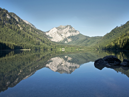
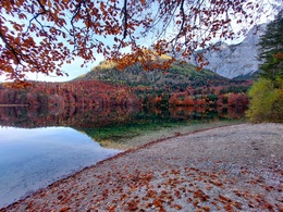
The lakes Vorderer and Hinterer Langbathsee are gloriously located alpine lakes, which invite to an amazing hike.
The laketurn starts at the parking lot of the lake Vorderer Langbathsee. Along the northern shore leads a signposted walk to a forest road. Those who don't want to need so much time, can turn left at the western shore of the lake Vorderer Langbathsee and walk back via the southern shore. During the walk to the lake Hinterer Langbathsee you surmount a terrace via the steadily increasing forest road. Passing a landslide landscape, in which the outflow of the see dries up, you reach the bank of the lake Hinterer Langbathsee where you have some benches to rest. The lake, in which the forest is reflected, and the cliffs of the Höllengebirge are an impressive motif. After a route around the lake you hike back to the lake Vorderer Langbathsee via a forest road. The last part leads back to your point of departure via a broad path.
Hiking-time:
Around both lakes: approximately 1 3/4 hours
Around the lake Vorderer Langbathsee: approximately 3/4 hours
Starting point: parking lot of the lake Vorderer Langbathsee
Destination: parking lot of the lake Vorderer Langbathsee
further information:
- Flatly
- Board possible
")
Accessibility / arrival
departure Regau- B 145 in the direction of Bad Ischl- turn right into the center of Ebensee- in front of the bridge turn right- in the direction of the Feuerkogel-alwayd straight ahaid till the Langbathsee
Parking- Parking space: 200
- Parking area for disabled: 2
- Bus parking space: 1
- All weather
- Suitable for groups
- Suitable for schools
- Suitable for kids (all ages)
- Suitable for pushchairs
- Suitable for teenagers
- Suitable for seniors
- Suitable for single travelers
- Suitable for friends
- Suitable for couples
- Suitable for children
- Spring
- Summer
- Autumn
- Early winter
Somewhat suitable for wheelchairs: Assistance is sometimes necessary. The measurements do not (fully) conform to the legally stipulated ÖNORM.
Hauptstraße 34
4802 Ebensee
Phone +43 6133 8016
Fax machine +43 6133 8016 - 870
E-Mail ebensee@traunsee-almtal.at
Web www.traunsee-almtal.at/ebensee
http://www.traunsee-almtal.at/ebensee
Interactive elevation profile
Create PDF
Tour-Details
Starting place: 4802 Ebensee
Destination: 4802 Ebensee
duration: 2h 3m
length: 7,0 km
Altitude difference (uphill): 167m
Altitude difference (downhill): 169m
Lowest point: 668m
Highest point: 768m
difficulty: easy
condition: easy
panoramic view: Great panorama
Paths covering:
Path / trail, Gravel, Street, Hiking trail
powered by TOURDATA


