Gerlhamer Moor in Seewalchen


- pets allowed
- All weather
- Suitable for families
- Suitable for kids (all ages)
- Flatly
Interactive elevation profile
Create PDF
Tour-Details
Starting place: 4863 Seewalchen am Attersee
Destination: 4863 Seewalchen am Attersee
duration: 2h 28m
length: 10,1 km
Altitude difference (uphill): 28m
Altitude difference (downhill): 29m
Lowest point: 472m
Highest point: 527m
difficulty: medium
condition: medium
panoramic view: Great panorama
Paths covering:
Asphalt, Gravel, Hiking trail
powered by TOURDATA
Fortunately luckplace pear tree court - a leisurely hike in the community Seewalchen
From the parish church is the one described Western Trail (the yellow signs) along the way to school through the woods and Dr. F.-C. Ginzkey way to Ginzkey monument.
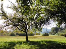
Through the woods on the "Mooser box" - Tostmannstraße - Kellerweg and Hofmann road on a meadow to the church in Buchberg. A short distance along the main road to Haining.
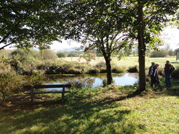
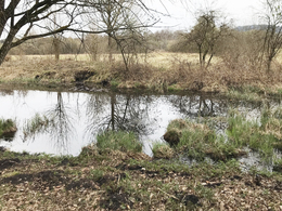
At the junction turn left back to Gerlham. Once in Gerlham it's worth a trip to the bog Gerlhamer "pear tree court" to make, which is reported as a lucky place.
At the turnoff to the village continue straight. After 50 meters turn left and pass through a book on forest grove Inger Bach. Here it goes straight to the Dr Shoe-road to school and back to the church.
Refreshments:
Ort Seewalchen am Attersee
From the parish church is the one described Western Trail (the yellow signs) along the way to school through the woods and Dr. F.-C. Ginzkey way to Ginzkey monument.
Through the woods on the "Mooser box" - Tostmannstraße - Kellerweg and Hofmann road on a meadow to the church in Buchberg. A short distance along the main road to Haining.
At the junction turn left back to Gerlham. Once in Gerlham it's worth a trip to the bog Gerlhamer "pear tree court" to make, which is reported as a lucky place.
At the turnoff to the village continue straight. After 50 meters turn left and pass through a book on forest grove Inger Bach. Here it goes straight to the Dr Shoe-road to school and back to the church.
Refreshments:
Ort Seewalchen am Attersee
Starting point: Parish Seewalchen am Attersee
Destination: Parish Seewalchen am Attersee
further information:
- Flatly
Accessible all year round
Please note, in winter there is no snow removal

 (© TVB Attersee-Attergau)")
")
Accessibility / arrival
Accessibility / Arrival:
by car:
From Salzburg via the A1 - Seewalchen exit
From Vienna/Linz via A1 - exit Schörfling or Seewalchen
From the west - Bad Ischl-Weißenbach-Steinbach-Weyregg-Schörfling parking lot Kmmer
by train:
Coming from Salzburg or Linz/Vienna to Attnang-Puchheim or Vöcklabruck - continue with the Kammer Bahn to BH Kammer Schörfling or with the bus stop Kammer-Agerbrücke or Seewalchen-Agerbrücke.
by plane:
From Salzburg via A1 - exit Seewalchen
from Vienna/Linz via A1 - exit Schörfling or Seewalchen
Parking is possible at the municipalty
- Parking space: 10
- All weather
- Suitable for groups
- Suitable for schools
- Suitable for kids (all ages)
- Pets allowed
- Suitable for teenagers
- Suitable for seniors
- Suitable for single travelers
- Suitable for friends
- Suitable for couples
- Suitable for children
- Spring
- Summer
- Autumn
- Early winter
- Deep winter
Please get in touch for more information.
")
Dorfstraße 33
4865 Nußdorf am Attersee
Phone +43 7666 7719 - 0
E-Mail info.schoerfling@attersee.at
Web attersee-attergau.salzkammergut.at
https://attersee-attergau.salzkammergut.at
You can also visit us on
Visit us on Facebook Visit our videochannel on YouTube Wikipedia")
")
")
Interactive elevation profile
Create PDF
Tour-Details
Starting place: 4863 Seewalchen am Attersee
Destination: 4863 Seewalchen am Attersee
duration: 2h 28m
length: 10,1 km
Altitude difference (uphill): 28m
Altitude difference (downhill): 29m
Lowest point: 472m
Highest point: 527m
difficulty: medium
condition: medium
panoramic view: Great panorama
Paths covering:
Asphalt, Gravel, Hiking trail
powered by TOURDATA


