East bank hiking trail on Lake Hallstatt


- pets allowed
- Suitable for families
- Suitable for kids (all ages)
- culinary interesting
Interactive elevation profile
Create PDF
Tour-Details
Paths covering:
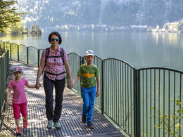
The east bank hiking trail from Steeg to Obertraun along Lake Hallstatt is one of the most beautiful hiking trails in the Salzkammergut. The easy adventure hike is particularly popular with families as it offers wonderful views as well as some special highlights.
The Ostuferwanderweg from Steeg to Obertraun
The approx. 3-hour adventure trail is accessible from both the village of Steeg and Obertraun. We start at Steeg railway station. From here, walk along the road to Metzgerwirt Vieh Heli. Past the Metzgerwirt, follow the hiking trail below the Arikogel to Untersee. Here you can decide whether to take a detour to Strandbad or cross the village, following the signs towards Lake Hallstatt.
At first, hikers and cyclists share the path.
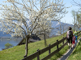
The hiking trail now leads between the lake and the railway along meadows and sparse forests until after approx. 1 hour you reach the Uferwirt Seeraunzn reached. It is worth taking a break here and enjoying the regional delicacies.
After the Uferwirt Seeraunzn the trail continues for around two kilometres separately. A short distance before the suspension bridge, the paths merge again.
We ask for mutual consideration between hikers and cyclists.
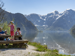
We follow the path along the lake and enjoy the lake landscape characterised by glacial ice and the imposing mountain backdrop. After around 45 minutes, we reach the Hängebrücke zum Wehrgraben - the deepest point of the lake at around 125 metres.
We then reach the Hallstatt railway station - the highest point of the hike at 520 metres. There are 2 options here: follow the path towards Obertraun or take the ferry a detour to the World Heritage Site Hallstatt.
We follow the path to the end point of the hike to Obertraun and reach the village near the strandbad approx. 5 minutes' walk from Obertraun train station. From here you can return by train or walk back the same way. In summer, you can take the boat back to Steeg. There is also the option to hike on to Hallstatt.
The path of many possibilities
The fifth largest lake in the Salzkammergut invites you to swim and linger in summer. In addition to the beach baths in Untersee and Obertraun, there are free accessible bathing stations and benches to relax on along the Ostuferwanderweg hiking trail.
We also highly recommend a boat trip on Lake Hallstatt. Either from the Hallstatt train station to the World Heritage town of Hallstatt or from Obertraun to Hallstatt or Steeg/Untersee.
Aspecial highlight along the Ostuferwanderweg trail is the Lindwurm - the symbolic animal of Bad Goisern's history. The Lindwurm stands outside the village of Untersee along the hiking trail and is one of the most photographed motifs on the hiking trail.
Desire for more hikes?
The Holiday Region Dachstein Salzkammergut entices you with the most beautiful hikes. Another family-friendly hike awaits you, for example along the Traun river at Traunreiterweg.
You can find more recommendations in our Overview of all hiking trails in the Dachstein Salzkammergut holiday region.
In case of emergency: Mountain Rescue 140
Experience a 360° panoramic tour through Bad Goisern on Lake Hallstatt...
further information:
- culinary interesting
Depending on the current snow and weather conditions from April to November.
The east bank hiking trail along Lake Hallstatt can be started from Bad Goisern or Obertraun. The ideal way to get there is by train either to Steeg train station or Obertraun train station. There are plenty of parking spaces for cars at Steeg train station, in Obertraun you should use the paid car park at the lido
By car
From Salzburg:
Exit Thalgau via federal road B158 towards Bad Ischl, in Bad Ischl take the exit onto the Salzkammergut road B145 towards Bad Goisern.
From Linz:
Regau motorway exit onto Salzkammergut Straße B145 towards Gmunden and Bad Ischl to Bad Goisern.
From Vienna/Graz:
Liezen motorway exit onto B320, in Trautenfels turn off onto Salzkammergut Straße B145 to Bad Goisern.
From Villach:
Tauern motorway to exit "Eben im Pongau", via B166 Pass Gschütt Bundesstraße through Gosau, turn left at the Gosaumühle junction towards Bad Goisern.
By train
Train Attnang-Puchheim - Stainach-Irdning:
Stops Goisern Jodschwefelbad, Bad Goisern railway station, Steeg / Gosau.
By bus
Bus 541 & 542 (Bad Ischl - Lake Gosau):
Stops Bad Goisern Jodschwefelbad, Bad Goisern Kurhotel, Bad Goisern Mitte/B145, Stambach StrKrzg., St. Agatha Agathawirt, Stambach Angerer, Steeg Reitern, Steeg Au, Steeg Bahnhof, Steeg Traunbrücke, Steeg E-Werk.
Detailed information on the respective Train- and Bus times can be found here!
- Free entry
- Suitable for groups
- Suitable for schools
- Suitable for kids (all ages)
- Pets allowed
- Suitable for teenagers
- Suitable for seniors
- Suitable for single travelers
- Suitable for families
- Suitable for friends
- Suitable for couples
- Suitable for children
- Spring
- Summer
- Autumn
Please get in touch for more information.
Kirchengasse 4
4822 Bad Goisern am Hallstättersee
Phone +43 5 95095 - 10
Fax machine +43 5 95095 - 74
E-Mail goisern@dachstein-salzkammergut.at
Web dachstein.salzkammergut.at/wandern
Web dachstein.salzkammergut.at
https://dachstein.salzkammergut.at
You can also visit us on
Visit us on Facebook Visit us on Instagram Visit us on TikTok Visit us on Pinterest Visit our videochannel on YouTube Wikipedia")
")
")
Interactive elevation profile
Create PDF
Tour-Details
Paths covering:


