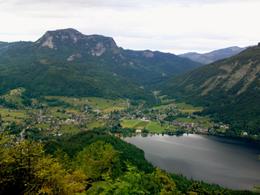
Lookout tower "Tressenstein"


- Suitable for families
Interactive elevation profile
Create PDF
Tour-Details
Starting place: 8990 Bad Aussee
Destination: 8990 Bad Aussee
duration: 2h 0m
length: 3,7 km
Altitude difference (uphill): 565m
Altitude difference (downhill): 25m
Lowest point: 655m
Highest point: 1.201m
difficulty: very easy
condition: easy
panoramic view: Dreamtour
Paths covering:
Asphalt, Path / trail, Street, Hiking trail, Other
powered by TOURDATA
Short description:
Mountainhike to a new viewpoint starting in Bad Aussee.
Mountainhike to a new viewpoint starting in Bad Aussee.
Quality of experience: ****
Recommended season:
- May
- June
- July
- August
- September
- October
Properties:
- Scenic
- Refreshment stops available
- Family friendly
- Summit route
Starting point: Bad Aussee, near to the former hospital
Destination: Lookout tower "Tressenstein"
further information:
- Board possible
Accessibility / arrival
Public Transit
The railway station ist located about 2,5 kilometers from the starting point of the tour. Public buses you shall find in the centre of Bad Aussee, as well as, some stopp also at the railway station in direction to Altaussee and Grundlsee via the centre of Bad Aussee.
Parking
Parking directly at the starting point available. Liable to fees!
Getting there
From the centre of Bad Aussee you have to follow the way in direction of Grundlsee. After passing a small square called "Meranplatz" you turn 200 meters later to the left to the parking, where the tour starts.
Detailed information how to get to the Ausseerland – Salzkammergut you will find on our website!
Public Transit
The railway station ist located about 2,5 kilometers from the starting point of the tour. Public buses you shall find in the centre of Bad Aussee, as well as, some stopp also at the railway station in direction to Altaussee and Grundlsee via the centre of Bad Aussee.
Parking
Parking directly at the starting point available. Liable to fees!
Most economical season
- Spring
- Summer
- Autumn
Please get in touch for more information.
Pratergasse 388
8990 Bad Aussee
Phone +43 3622 54040 - 0
E-Mail info@ausseerland.at
Web www.ausseerland.at
http://www.ausseerland.at
Interactive elevation profile
Create PDF
Tour-Details
Starting place: 8990 Bad Aussee
Destination: 8990 Bad Aussee
duration: 2h 0m
length: 3,7 km
Altitude difference (uphill): 565m
Altitude difference (downhill): 25m
Lowest point: 655m
Highest point: 1.201m
difficulty: very easy
condition: easy
panoramic view: Dreamtour
Paths covering:
Asphalt, Path / trail, Street, Hiking trail, Other
powered by TOURDATA


