Baby buggy - tour: R. Eybner-Promenade to Grundlsee
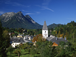
Starting place: 8990 Bad Aussee
Destination: 8993 Grundlsee


Pratergasse 388
8990 Bad Aussee
8990 Bad Aussee

Short description:
Pathway in the shade, along the river which leads to Grundlsee without nameable differences in altitude suitable for baby buggies.
Pathway in the shade, along the river which leads to Grundlsee without nameable differences in altitude suitable for baby buggies.
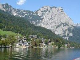
The lake Grundlsee ist the biggest lake in Styria and a paradise for its visitors.
Quality of experience: ****
Recommended season:
- April
- May
- June
- July
- August
- September
- October
- November
Properties:
- Refreshment stops available
- Family friendly
- Suitable for strollers
Starting place: 8990 Bad Aussee
Destination: 8993 Grundlsee
duration: 1h 15m
length: 3,8 km
Altitude difference (uphill): 73m
Altitude difference (downhill): 27m
Lowest point: 657m
Highest point: 731m
difficulty: very easy
condition: very easy
panoramic view: Dreamtour
Paths covering:
Asphalt, Path / trail, Street, Hiking trail
Starting point: Bad Aussee, "alley Kirchengasse"
Destination: Village and lake Grundlsee
further information:
- Board possible

Accessibility / arrival
Public Transit
Railway station nearby: Bad Aussee
Parking
Parking nearby the starting point available!
Getting there
Nähere Information zur Anreise in das Ausseerland – Salzkammergut finden Sie auch auf unserer Homepage!
Public Transit
Railway station nearby: Bad Aussee
ÖBB (train): www.oebb.at
Verbundlinie Steiermark (bus): www.busbahnbim.at
Public transport service Narzissenjet:
www.ausseerland.at/narzissenjet
Parking
Parking nearby the starting point available!
- Suitable for pushchairs
- Suitable for families
- Spring
- Summer
- Autumn
- Early winter
Please get in touch for more information.
Pratergasse 388
8990 Bad Aussee
Phone +43 3622 54040 - 0
E-Mail info@ausseerland.at
Web www.ausseerland.at
http://www.ausseerland.at


