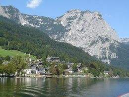
Enjoyable leisure hike "Grundlsee - Toplitzsee"


8993 Grundlsee

For this hike it is recommended to combine it with the local shipping. The Kammersee, which is part of the Three Lakes Tour and only accessible by traditional boats , the so-called "Plättn".
In some parts of the route you will find information boards of the theme hike called "Geo-Trail", which starts at the south bank of the Grundlsee and leads via Gößl finally to the Toplitzsee. At the north bank of the biggest lake in Styria, the Grundlsee, we follow the route "VIA ARTIS", which is a kind of learning path informing about artists, who were living or at least appeared somehow in the area.
Quality of experience: ****
Recommended season:
- May
- June
- July
- August
- September
- October
Properties:
- Loop
- Scenic
- Refreshment stops available
- Family friendly
- Geological highlights
Not later than at the Toplitzsee dining local fish you will realise why this tour is defined as "enjoyable".
The Geo-Trail informs its visitors well-represented about the evolutionary history and origin of the Salzkammergut. Millions of years ago a geologic process formed the today's region "Ausseerland-Salzkammergut".
34 information boards guide you through the development of the area. During the walk to the Toplitzsee you will learn about the orogenesis of the local mountains, the Ice Age and its effects to the landscape.
Directions:
From the first parking there are just few steps on the cycle path which brings you straight to the Grundlsee in few minutes. After the Seehotel at a narrow point we turn to the left upwards. 150 meters further up you reach the path which leads hightened parallel to the street along the lake to the east. On graveled and taramac we carry on walking this way without turning. In the area called "Gaiswinkel" at the taramac road first we turn left and then again right. Passing the local carpenter "Amon" we take the small road to the left and follow this until we are at the gravel pit. There is located the big fish farm of the Austrian Federal Forestry Company. Further we carry by following the signs to Gößl, where at the roundabout we turn to the right. Reaching the tradtional inn "Gasthof Veit" the graveld road brings us to the Toplitzsee. At the fishing hut there is the landing for boats in order to take a journey to the Kammersee.
Back at the fishing hut and after a rest we take the way back to Gößl via the path "Reith" where there reminds a monument on the first sight of the archduke with the daughter of a local postmaster at that time. After a path through the forest and again on a graveld road soon you reach Gößl.
Another way back to Gößl leads along the "Toplitz-Parcour" along the river.
In Gößl you can take the way back to the starting point by boat.
Also you can walk along the south bank of the lake via the area "Wienern". First on a taramac street and a graveld road then on a small path we walk along this ways straight ahead untill finally you reach again the "Seeklause".
Baby buggies and wheelchairs:
The tour alon the taramac roads and graveld pathes until the Toplitzsee are for baby buggies accessible and in general suitable for wheelchairs until the Toplitzsee via the village Gößl. For the way back it is recommended to take the same way or go back by boat.
The south bank is impassable for baby buggies and wheelchairs!
Safety guidelines:
Please note the exclusion of liability!
Equipment:
leichte Wanderausrüstung, evtl. Regenschutz
Additional information:
Accommodation in our region!
Various events you will find here!
Paths covering:
further information:
- Flatly
- Board possible
Getting there
Detailed information how to get to the Ausseerland – Salzkammergut you will find on our website!
Public Transit
With the train to the railway station in Bad Aussee and with the public bus to Grundlsee
Parking
Parking "Fischersteg", before you reach the lake.
Liable to fees!
- Spring
- Summer
- Autumn
Please get in touch for more information.
Mosern 25
8993 Grundlsee
Phone +43 3622 8666
E-Mail info.grundlsee@ausseerland.at
Web www.ausseerland.at


