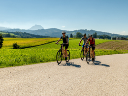
Traunviertel Bike Path R13


- Suitable for families
Interactive elevation profile
Create PDF
Tour-Details
Path number: R13
Starting place: 4552 Wartberg an der Krems
Destination: 4663 Laakirchen
duration: 2h 9m
length: 29,2 km
Altitude difference (uphill): 328m
Altitude difference (downhill): 270m
Lowest point: 383m
Highest point: 539m
difficulty: easy
condition: easy
panoramic view: Great panorama
Paths covering:
Asphalt
powered by TOURDATA
The Traunviertel Bike Path provides a connection between the Kremstal Bike Path via the Almtal and the Traun Bike Path.
In Wartberg an der Krems, you turn off of the Kremstal Bike Path and traverse the hills between the valleys of the Krems, Alm and Traun on mostly paved country roads. Whilst on your way, you may have to conquer an incline or two.
In Pettenbach and Vorchdorf, the R 13 crosses the R 11, the Almtal Bike Path on the way from Lake Alm to Wels.
Designation: R13 (Within the network of national bike paths in Upper Austria)
Starting point: Kremstal Bike Path in Wartberg an der Krems
Destination: Traun Bike Path in Laakirchen
further information:
- Board possible
Accessibility / arrival
by train:
Take the Pyhrnbahn, line 140, from direction Linz or direction Selzhtal to the Wartberg / Krems train stop. From the train station in the direction of the village exit in direction to Pettenbach
by car:
A1 - A9 - exit Ried im Traunkreis - B138 "Pyhrnpass" road - left on "Wartberger Straße" to the village of Wartberg
- Suitable for groups
- Suitable for friends
- Suitable for couples
- Spring
- Summer
- Autumn
Please get in touch for more information.
Freistädter Straße 119
4041 Linz
Phone +43 732 221022
Fax machine +43 732 7277 - 701
E-Mail info@oberoesterreich.at
Web www.oberoesterreich.at/landesradweg…
https://www.oberoesterreich.at/landesradwege
Interactive elevation profile
Create PDF
Tour-Details
Path number: R13
Starting place: 4552 Wartberg an der Krems
Destination: 4663 Laakirchen
duration: 2h 9m
length: 29,2 km
Altitude difference (uphill): 328m
Altitude difference (downhill): 270m
Lowest point: 383m
Highest point: 539m
difficulty: easy
condition: easy
panoramic view: Great panorama
Paths covering:
Asphalt
powered by TOURDATA


