landscape track (95)


- All weather
- culturally interesting
- Flatly
Interactive elevation profile
Create PDF
Tour-Details
Starting place: 5322 Hof bei Salzburg
Destination: 5322 Hof bei Salzburg
duration: 2h 18m
length: 12,7 km
Altitude difference (uphill): 613m
Altitude difference (downhill): 398m
Lowest point: 739m
Highest point: 936m
difficulty: medium
condition: medium
panoramic view: Some Views
Paths covering:
Hiking trail
powered by TOURDATA
information: Akutmeldung/Information
Description: Red Cross: 144
internat. emergency call: 112
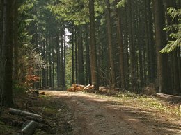
We are living in a cultural landscape affected and shaped by humans. The development nature from its original form as a purely natural landscape to a cultural landscape is shown on this way.
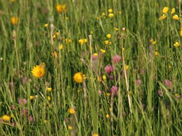
On this tour you will see the beautiful landscape of the Fuschlseeregion.
After ca. 25 minutes you reach the so-called "Hofer Sattel". A short departure from “our” way in the direction of the Lidaun allows you to obtain a wonderful view in the direction of Salzburg and the mountain Gaisberg. The way back also leads along an unimproved forest road with several twisted roads into the small settlement of “Nussbaumersiedlung”, from where we get back on the road to Hof.
For those who still haven't had enough, there remains the possibility of walking along the road through the settlement, which leads right over a bridge, where you reach a steep path which leads along the old forest festival grounds in the direction of the retirement home. (Waldspur).
The way is partially suited for baby carriage.
further information:
- Flatly
- Board possible
Details - hiking
- themed path

Landschaftsentwicklung

Kulturlandschaft

Blick vom Hofer Sattel
Alternativer Abzweig
Accessibility / arrival
Take the Wolfgangseestraße in the direction of Fuschl. The Tourism Association is situated on the right side opposite the Raiffeisen-bank and the optician Optik Fröhlich.
- All weather
- Suitable for groups
- Suitable for schools
- Spring
- Summer
- Autumn
- Early winter
Please get in touch for more information.
Postplattenstraße 1
5322 Hof bei Salzburg
Phone +43 6226 8384 - 21
E-Mail hof@fuschlseeregion.com
Web fuschlsee.salzkammergut.at/die-regi…
http://fuschlsee.salzkammergut.at/die-region/oesterreich/tour/430001131/landschaftsspur-95.html
Interactive elevation profile
Create PDF
Tour-Details
Starting place: 5322 Hof bei Salzburg
Destination: 5322 Hof bei Salzburg
duration: 2h 18m
length: 12,7 km
Altitude difference (uphill): 613m
Altitude difference (downhill): 398m
Lowest point: 739m
Highest point: 936m
difficulty: medium
condition: medium
panoramic view: Some Views
Paths covering:
Hiking trail
powered by TOURDATA


