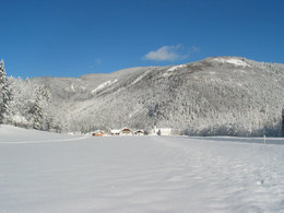
Hintersee - village cross country skiing trail
Starting place: 5324 Hintersee
Destination: 5324 Hintersee
Not in operation
10 km gentle area invite you to do cross-country skiing. The trail leads you along streams , through the forest and partly sunny snowy meadows let you forget everyday life .
Cross country ski tickets are available at the Tourist Office in Hintersee and at the Hotel DAS Hintersee.
- Day ticket € 9.-
- Season ticket € 85.-
Starting place: 5324 Hintersee
Destination: 5324 Hintersee
duration: 3h 54m
length: 14,4 km
Altitude difference (uphill): 204m
Altitude difference (downhill): 203m
Lowest point: 720m
Highest point: 819m
difficulty: medium
condition: easy
panoramic view: Some Views
Paths covering:
snow
Starting point: Fire brigade house or at the ski lift
further information:
- Board possible
Details - Trail
- Nordic skiing facilities: Marked Nordic skiing run
- Type of Nordic skiing run: Classic style
depends ond snow conditions

Abzweigung nach Hintersee
Abzweigung nach Lämmerbach
Blick nach Süden
Brücke über den Tiefenbach
Einstiegstelle in Hintersee
Gemeindezentum Hintersee mit Einstiegstelle
Gennerhorn und Gruberhorn
Kirche von Hintersee mit Pfarrhof
Landesstraßen
Loipe im Wald
Loipe mit Jagdhaus
Loipe mit Sonnberg
Wendepunkt Talstadion Skilift
General price information
- Season 2024/25:
- 1 Day ticket € 9,00
- Season ticket € 85,00
Payment methods
Cash payment
- All weather
- Suitable for groups
- Suitable for schools
- Suitable for teenagers
- Suitable for seniors
- Suitable for single travelers
- Suitable for families
- Suitable for friends
- Suitable for couples
- Suitable for children
- Early winter
- Deep winter
Please get in touch for more information.
Lämmerbach 50
5324 Hintersee
Phone +43 6226 8384 - 71
E-Mail hintersee@fuschlseeregion.com
Web fuschlsee.salzkammergut.at
https://fuschlsee.salzkammergut.at
powered by TOURDATA


