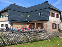
Hochlecken from Lake Taferklause


- Possible accommodation
Interactive elevation profile
Create PDF
Tour-Details
Starting place: 4853 Steinbach am Attersee
Destination: 4853 Steinbach am Attersee
duration: 3h 30m
length: 7,5 km
Altitude difference (uphill): 982m
Altitude difference (downhill): 872m
Lowest point: 621m
Highest point: 1.574m
difficulty: difficult
condition: difficult
panoramic view: Great panorama
Paths covering:
Gravel, Hiking trail
powered by TOURDATA
Hiking trail no. AV 826
This charming alpine hike leads along very well-marked paths to the 1572 m high, serviced Hochleckhaus in the middle of the Höllengebirge mountains. A magnificent panorama of Lake Attersee awaits us on this challenging tour. Stamina and surefootedness are required.
The starting point of this route is Lake Taferlklaussee. From there, you first hike southwards on a forest road above a gravel pit slightly uphill. The route continues via the Aurachursprung spring in many small hairpin bends through a wooded area to the Aurachkar and the Antoniusbründl, which invites you to take a well-earned rest. The route continues upwards in serpentines through the cirque, where the path turns right after a steep step. Here you have the option of taking path no. 827 to the Hochleckenkogel.
The path to the Hochleckenhaus leads to the right to the rocky head of the "Jausenstein". After a hollow, the trail climbs steeply uphill before finally crossing open areas up to the Hochleckenhaus. Surefootedness is required during this section.
Refreshments:
Hochleckenhaus (open from Easter to the end of October, overnight accommodation available)
Parking
- Parking space: 10
- Suitable for teenagers
- Suitable for single travelers
- Suitable for friends
- Suitable for couples
- Spring
- Summer
- Autumn
Please get in touch for more information.
Steinbach am Attersee 5
4853 Steinbach am Attersee
Phone +43 7666 7719 - 60
E-Mail info.steinbach@attersee.at
Web attersee-attergau.salzkammergut.at
Web www.bergsteigerdoerfer.at/18-0-Berg…
https://attersee-attergau.salzkammergut.at
http://www.bergsteigerdoerfer.at/18-0-Bergtouren-rund-um-Steinbach-am-Attersee.html
http://www.bergsteigerdoerfer.at/18-0-Bergtouren-rund-um-Steinbach-am-Attersee.html
You can also visit us on
Visit us on Facebook Visit us on Instagram Visit our videochannel on YouTube WikipediaInteractive elevation profile
Create PDF
Tour-Details
Starting place: 4853 Steinbach am Attersee
Destination: 4853 Steinbach am Attersee
duration: 3h 30m
length: 7,5 km
Altitude difference (uphill): 982m
Altitude difference (downhill): 872m
Lowest point: 621m
Highest point: 1.574m
difficulty: difficult
condition: difficult
panoramic view: Great panorama
Paths covering:
Gravel, Hiking trail
powered by TOURDATA


